For Kathmandu to Pikey Peak, you will first travel to the trek starting point-Dhap Bazaar and Phaplu by road and flight to begin your trek to Pikey peak. The most popular and budget-friendly method is to take a shared public jeep or a private jeep to Dhap, the main starting point for the Pikey Peak trek.
Kathmandu to Pikey Peak Jeeps leave early in the morning at around 5:00 AM from Kathmandu. The drive is long and can take 8 to 10 hours, depending on road conditions and traffic. The roads can be bumpy, especially the final stretch. It costs approximately USD 25 to USD 35 per person.
The Private Jeep journey from Kathmandu to Pikey Peak is faster and more comfortable, typically taking 6 to 7 hours. A private jeep for the round trip can cost between USD 400 to 500 (one way around USD 200-250). It offers greater comfort, flexibility, and a shorter travel time.
Flight and Road Travel finishing point-Phaplu is recommended. You can save significant time on the return journey by flying back to Kathmandu from Phaplu, a nearby airstrip. Kathmandu to Dhap travel by jeep as described above to begin your trek.
Phaplu to Kathmandu by bus/jeep after completing the trek which typically ends in Phaplu or Salleri, you can also take a short flight. The flight takes about 30 minutes. The flights typically cost around USD 180 per person. Flights are not daily, so booking in advance is essential. You can also take a shared or private jeep from Phaplu/Salleri back to Kathmandu that takes 8 to 10 hours.
Kathmandu to Pikey Peak Distance
The driving distance from Kathmandu to the trailhead of the Pikey Peak Trek is approximately 230 to 280 km, taking about 7 to 10 hours by road to reach Dhap or Salleri, the common starting and ending points. The total driving distance for the entire trek, from Kathmandu to Salleri and back, is about 515 to 523 km.
Kathmandu to Pikey Peak trailhead by overland
Kathmandu to Dhap is drive of about 230 km, taking 7 to 9 hours by jeep. This is a common starting point for the trek. Kathmandu to Salleri is a drive of about 270 km, taking 7 to 8 hours. This is often the end point of the trek.
The Total Distance Of The Trip
The total driving distance is approximately 515 km to 523 km, depending on the exact route and starting/ending points. This includes the drive to Dhap and the drive back from Salleri. The total distance of pikey peak trek will vary depending on the specific itinerary and the route chosen for the trek itself, which is approximately 55 km to 60 km. Below is some of our particular pikey peak trek itinerary.
The trek from Pokhara to Annapurna Base Camp (ABC) is a multi-day hike of 7 to 14 days, depending on the route and stops. The journey typically begins with a drive from Pokhara to a starting point like Nayapul, Siwai, Ghandruk or Ulleri followed by trekking through various villages to reach ABC at an altitude of 4,130 meters. The total trek distance is about (115 to 120) km, though this can vary based on your specific path and side trips.
Ghandruk is a beautiful Gurung village offering stunning views of the Annapurna and Machapuchare mountains. Chhomrong is a key village on the main route, offering more spectacular views. Machapuchare Base Camp (MBC) is located at 3,700 meters, this is the last stop before ABC and offers incredible views of the “Fishtail” mountain. Annapurna Base Camp (ABC) at an elevation of 4,130 meters, this is the final destination, where you are surrounded by a magnificent amphitheater of Himalayan peaks.
ABC Trip Distance and Cost for Meals and Accommodation
The Annapurna Base Camp round trip from the starting point near Pokhara to ABC is approximately 70 kilometers, with a total distance of up to 95 kilometers including the journey from Pokhara.
The Annapurna Base Camp route has teahouses that provide accommodation and meals. For food and accommodation, approximately $30 per day is often sufficient, while guides and porters cost extra.
Annapurna Conservation Area Permit (ACAP) is required to enter the Annapurna Conservation Area. TIMS (Trekkers’ Information Management System) card is also required for trekking to Annapurna base camp.
You can trek independently, obtaining your own permits and arranging accommodation. Many choose to hire a guide and porter for a guided tour to ABC. Book a fully organized tour through a local company. A professional guide may cost $30 and more per day, while a porter costs around $25 per day.
The most popular seasons for the ABC trek-Spring (March–May) features clear skies and rhododendron blooms. Autumn (September–November) offers stable weather and excellent mountain views.
The ABC trek is considered moderately difficult. It is accessible to anyone with a moderate level of fitness and the right preparation. The itinerary allows for a gradual ascent, which helps with acclimatization to the high altitude.
Kathmandu to Pokhara Travel Ways
There are three primary ways to travel from Kathmandu to Pokhara by air, tourist bus, and private car. The best option for you depends on your budget, time, and comfort preferences.
Kathmandu to Pokhara by flight
Flying is the fastest and most comfortable option, with flights lasting only 25 to 30 minutes. The major carriers serving this route include Buddha Air and Yeti Airlines.
Flights are significantly more expensive than ground transport. Prices vary depending on demand, but a one-way ticket can start around $100–$140.
Flights offer greater schedule flexibility and save a full day of travel time. However, delays and cancellations are common, especially during the monsoon season, due to adverse weather.
Kathmandu to Pokhara by tourist bus
Taking a tourist bus is a popular and budget-friendly choice, offering a scenic journey along the Prithvi Highway. The trip can take 7 to 10 hours, but significant delays from roadworks, traffic, and accidents can extend the travel time.
The Buses typically depart every morning around 7:00 AM from Kathmandu. While more affordable than a flight, road conditions can be bumpy. For a more comfortable trip, many travelers recommend booking a “luxury” or “deluxe” bus, which features air conditioning and better seats. The standard bus tickets cost around USD 12 to USD 20 per person.
Kathmandu to Pokhara by private car
A private car provides a balance of comfort and flexibility between flying and taking the bus. A private vehicle typically takes 6 to 7 hours, including a stop for lunch. However, delays due to traffic and road conditions are still possible.
This option allows you to stop for breaks and photos along the way and travel at your own pace. A private car is more expensive than the bus but can be cost-effective for a small group. A car ride can cost around $130 for up to four people. The route follows the Prithvi Highway and features scenic drives along rivers like the Trishuli and Marsyangdi.
Mount Makalu, the 5th highest mountain in the world.
Mount Makalu Nepal is the fifth-highest peak on Earth, lying on the Nepal-Tibet border, famous for trekking and climbing in Nepal. Learn more about the towering beauty of Mt Makalu, including its first ascent, permits, routes, and the number of days of trekking and climbing.
Mount Makalu Nepal Facts
Height: 8,485 meters / 27,838 feet First Ascent: May 15, 1955, by Lionel Terrey and Jean Couzy Location: Nepal/Tibet border in Mahalangur Himalayas Deaths: 35 (as of 2022) Summit Success Rate: 34%
Key Notes of Mt Makalu Nepal
Distinctive Pyramid Summit The Makalu summit is characterized by its pyramid shape, a distinctive feature that sets it apart from other peaks. The sharp angles of the Makalu summit create a captivating silhouette against the backdrop of the Himalayan sky.
Challenging Ascent Makalu presents a formidable challenge to climbers, earning its reputation as one of the most technically demanding climbs in the world. The ascent involves navigating steep rock walls, ice slopes, and unpredictable weather conditions, testing the skills and resilience of even the most experienced mountaineers.
Makalu Climbing Routes Makalu offers various climbing routes, each with its own challenges and rewards. The most popular route is the standard Southeast Ridge, known for its technical difficulty and breathtaking views. Other paths – the West Pillar and the Northeast Ridge, provide alternative options for seasoned climbers.
Stunning Panoramas The summit of Makalu offers panoramic views of some of the world’s highest peaks, including Everest, Lhotse, and Kanchenjunga. The expansive vistas from Makalu’s peak are a visual feast, rewarding climbers with an unparalleled experience of the Himalayan landscape.
Untouched Wilderness Makalu’s remote location and challenging terrain contribute to the preservation of its pristine wilderness. The surrounding Makalu Barun National Park, a biodiversity hotspot, is home to a diverse range of flora and fauna, making the region a haven for nature lovers and conservation enthusiasts.
History of Makalu Ascents
For centuries, Makalu remained an unknown peak shrouded in clouds and mystery. It was only identified as the world’s fifth highest in the 1850s. After an expedition in 1954, a French team made the first ascent in 1955, two years after the first ascent of Everest (the highest mountain in the world).
The technical difficulty and isolation of Makalu and political restrictions meant few attempts in the early years. By 1970, there were only six successful summits. A legendary American team in 1970 finally conquered the southwest Makalu face.
In the modern era, easier access and routes have enabled more expeditions. But the summit success rate still hovers around 34%, making Makalu among the hardest 8000ers to climb. Storms, avalanches, and technical rock sections regularly turn back teams each season.
Mount Makalu Climbing Permits Costs Makalu-Barun National Park Entry Permit Nepal Government royalty fees Makalu permit (Peak climbing permit) per person, issued by Nepal Mountaineering Association (NMA) Liaison officer expenses (Mandatory for teams) Visa costs for Nepal Flights to/from Kathmandu Insurance, food, supplies, oxygen, etc. We suggest you contact an experienced operator to make the complex logistical and permitting process smoother. You should prepare for the permits 4-6 months in advance of your climb.
Best time to climb Mount Makalu The best time to climb Makalu is either spring or autumn. Spring is the most favorable due to the right temperature and the clear skies. In spring, April, March, and May months are popular. You can also climb Makalu during autumn in September, October, and November.
Climbing Makalu The first step for a Makalu climb is securing a permit. It is an essential step for mountaineers undertaking this challenging expedition. The permit, issued by the Nepalese government, ensures that climbers adhere to regulations designed to preserve the environment and promote responsible mountaineering.
Acclimatization The climbing journey typically begins with an acclimatization process, allowing climbers to adapt to the high-altitude conditions. The trek to Makalu Base Camp, situated at approximately 4,800 meters, serves for acclimatization and preparation for the ascent.
Routes on Mount Makalu Southeast Ridge: This is the original and most common route, first climbed in 1955. It follows the long Southeast ridge, joining the main summit ridge. However, this route is highly prone to rockfall and avalanches, yet this route is not as technical as the northeast ridge.
Northeast Ridge: A direct route first climbed in 1971 involving steep snow, ice, and mixed terrain. It joins the southeast ridge higher up. This path is steeper and harsher to climb than the southeast ridge.
West Pillar – This is a technical route first climbed in 1971 that meets the southern ridge just below the summit. The route is exposed, and the strong winds are frequent.
West Face – Among other routes, this is the most challenging route as it passes through avalanche-prone areas with huge serac barriers. This route was first summited in 1997. All routes require expertise in rock, snow, and ice climbing. Southeast Ridge is the most commonly taken route.
Southeast ridge of Mt. Makalu Southeast ridge is the most frequented route to Makalu Peak. Here are the climbing details through this route.
Makalu Base Camp (5600M): Reaching Makalu Base Camp is the first step for a Makalu Expedition. This base camp serves as the preparation and an acclimatization point for the Makalu expedition.
Makalu Camp 1 (6400m): Once prepared at the Base Camp, you will head to Camp 1. The path passes through rock slabs and moraine before reaching a glacier. It will take around three to four hours to reach the first Camp. The first Camp consists of two sections – lower and upper.
Makalu Camp 2 (6800m): The path from Makalu Camp 1 and Makalu Camp 2 is intermediate in terms of climbing complexity. You will have to cross several steep ice areas. Though you do not need a ladder to complete this section, you must take support from ropes. The average time to reach Camp 1 to Camp 2 is around three hours.
Makalu Camp 3 (7450m): This is the longest section between the camps. You will have to cross a few crevasses and follow the ropes placed by Sherpas. It will take around four hours to reach Camp 3 from Camp 2.
Makalu Camp 4 (7900m): The distance between Camp 3 to Camp 4 is short, but due to altitude and the rough terrain, the climb gets progressively harder as you get closer to the death zone. Due to low oxygen levels, you must push yourself. It will take around 3 hours to reach Camp 4 from Camp 3 as you conquer the route that averages around 50 percent.
Makalu Summit (8485m): After setting up a series of camps along the mountain for acclimatization, the summit push begins from Makalu Camp 4 before midnight to reach the summit at daylight. You must brave 50-60-degree snow slopes using fixed ropes to negotiate steep rock bands and ice cliffs while fighting exhaustion, oxygen deprivation, and bitter cold (-40 C). This 12-18 hour push requires every ounce of strength and stamina. Teamwork is crucial to getting through complex sections. The summit rewards those who endure but comes at a heavy price.
The Challenges of climbing Mount Makalu Makalu is extremely dangerous, and underestimating the mountain can be fatal. You must be ready to face the challenges like
Altitude sickness, edema, exhaustion Sudden blizzards and whiteouts Massive avalanches and ice/rock falls Deep hidden crevasses Cornices and exposed knife-edge ridges Technical climbing errors and accidents You must stay within your limits, plan carefully, trust Sherpa’s judgment, and turn back in time to survive this peak. Makalu continues to claim lives each year.
Is Makalu Right for You? Before embarking on a Makalu expedition, you must honestly assess the skills and experience required. Ask the following questions. Makalu is not to be underestimated. Come prepared for the challenge of a lifetime with humility, caution, and respect for the mountain. The rewards of standing atop this iconic Himalayan pyramid are immense but earned only through determination, suffering, and accepting real risk. Few peaks transform climbers like Makalu.
About Makalu Trekking
Makalu Trek takes you to Makalu Base Camp is in the heart of Makalu-Barun National Park in the Eastern Nepal. Makalu Base Camp Hike is ideal for an experienced trekkers to explore wilderness and stunning natural scenery of Makalu region. Mt Makalu is the 5th highest peak in the world and famous for its outstanding diversity of flora and fauna.
Makalu, an off-the-beaten-path trek in the Himalayas of Nepal presents an intense physical challenge compared to other treks in Nepal. Makalu Trek takes most trekkers at least 8 days to reach Makalu Base Camp (5,050 m). Trekkers then need to retrace their steps on 5 to 6-day journey back out the same way they came in.
At the base camp of Makalu offers a clear view of the mountain. Each morning, you can watch the sunrise over the summit of the fifth tallest mountain in the world. A short walk up the slopes from basecamp reveals incredible views of Everest and Lhotse. The Makalu Base Camp Trek is perfect for adventurers who are looking to avoid the crowded trekking routes of Nepal to experience an authentic experience of trekking amongst the giants of the Himalayas.
Highlights of Makalu Trek
View points
Makalu is derived from the Sanskrit, Maha Kala, which is a name for the Hindu God Shiva. When you stand at base camp and stare up at Makalu you could feel as if you’re in the presence of the gods.
Local life
The villages and trails of Makalu region are a mish-mash of peoples, cultures and religions. In the higher villages live the Buddhist Sherpas, originally from eastern Tibet, while the Rai people, many of whom still follow the ancient Kranti religion, live at lower levels. Whatever their background the welcome is always a warm one.
Bio-diversity
Makalu forms the heart of the Makalu-Barun National Park, a super diverse 2,330sq-km protected area with an 8,000m vertical spread of elevation, ranging from tropical river valleys to the frozen summits of some of the world’s biggest mountains. Not surprisingly, there’s a huge diversity of life and growing species of flowering plants. There’s also the full spectrum of wildlife, from snow leopards to red pandas; black bears to sunbirds.
Exploration possibilities
Almost all of the people who trek Makalu take a simple up and down route along the same path. For those with plenty of time and stamina, and who are very well-equipped with a full, experienced expedition-style support team, there are wildly exciting treks to Kanchenjunga or even Everest.
The Mount Makalu Trek Routes
A. Makalu Base Camp
There’s only one standard route to Makalu base camp and it’s a simple there and back along the same trail. But this is a real wilderness trek and there are only permanent villages for the first and last couple of days. Most of the time the only other people you’ll meet are herders with their yaks. One of the highlights of this trek is camping in gorgeous spring flower meadows well away from other people and waking to soaring mountain views.
Once you clear the villages the route climbs steeply through forests, crosses the high and often snowy Shipton Pass (4,127m; named after Eric Shipton who followed this route with Sir Edmund Hillary during the 1952 Everest reconnaissance expedition) and then goes along the Barun Valley past rapids and waterfalls. Eventually, after crossing scree fields and landslide debris, the valley opens out and you arrive at base camp.
The view at base camp will send shivers of wonder down your spine, but climb up to the nearby ridge on Peak 3 for even more stunning Makalu views as well as side views of Lhotse, Lhotse Sar and Everest. You’ll probably be the only person up there.
B. Fact of Makalu Base Camp Trek
Difficulty: Difficult.
Lots of steep up and down and the fast elevation gain means the risk of altitude sickness is high. Trek Duration: 14 days Max Elevation: 4,870m Accommodation: Camping; very basic herders’ tea houses. Start/End Point: Num
Makalu Circuit Trek(Makalu to Everest)
One of the most challenging treks, the Makalu to Everest traverses via the very high passes of Sherpani (6,135m), West Col (6,143m), Baruntse Base Camp (5,700m) and Amphu Laptsa (5,850m) before descending into the Everest region at Pangboche. You should allow a minimum of three weeks for this trek and a lot more if you want to explore the Everest region in depth. You will need full expedition equipment, an experienced team, mountaineering experience and to be prepared for many nights’ camping above 4,500m.
Facts Of Makalu Circuit Trek
Difficulty: Very strenuous. Borderline mountaineering. Trek Duration: Minimum 21 days Max. Elevation: 6,143m Accommodation: Camping; very basic herders’ tea houses, trekking lodges. Start/End Point: Num/Lukla
Makalu to Kanchenjunga Trek
In recent years a few daring groups have launched expedition-style treks that link Makalu with Kanchenjunga via the 5,160m Sumba Lumba pass. It takes almost four weeks and a lot of determination, but for most people it’s a slightly more realistic proposition than the Makalu to Everest trek mentioned above. Like that trek, you need to approach it as a full expedition and have experience at high altitude and basic mountaineering skills.
Fact of Makalu to Kanchenjunga
Difficulty: Very strenuous/borderline mountaineering. Trek duration: 25 days Max elevation: 5,160m Accommodation: Camping/basic tea houses Start/end point: Num/Taplejung
Attractions of Makalu Circuit Trek
Makalu Circuit Trek is a challenging trek that takes you through breathtaking landscapes, remote villages, and high altitudes, offering stunning views of the Himalayas. The trek typically takes about 14-25 days to complete, depending on the itinerary and the trekker’s pace. It is compulsory for all international trekkers to have a licensed guide for hiking. It is nice to organize a guide through a good trekking company. It is an easier option because they will arrange a guide for you and plan your entire trip. Just make sure you will have a reliable guide with the license.
Makalu Trek Difficulty
The Makalu Base Camp Trek is slightly more difficult than Everest Base Camp or the Annapurna Circuit due to the incline, remoteness, and rugged nature of the trails. You will reach an altitude of 5000m, which will challenge many. Altitude sickness can be common. The route has lots of undulation with several days purely walking upstairs on stairs. These days of ascent are tiring and also require the body to adjust quickly.
Makalu Circuit Trek Permits
You will need a Makalu Barun National Park Conservation Area permit (USD $30 per person and a Trekkers’ Information Management Systems (TIMS) card (USD $20 per person) to do Makalu Trek.
Best Seasons for Makalu Trek
The peak season for the Makalu Base Camp Trek is March to April and October to November. The time to avoid this trek is during the rainy season from June to August. During the winter from December to February, this region gets very cold and there will be snow cover in the higher parts of the trek. Many of the guesthouses actually close up for the winter and re-open in late February to March. However, it is possible to hike the Makalu Base Camp Trek on the fringe of the season in late February/early March and it can be quite beautiful with snow cover.
Hike to Makalu Base Camp Trek in late April/early May and it will be warm during the day and got pretty cold at night. The Shipton La had good snow cover but other than that the paths were clear. We did not need crampons.
Is guide necessary for trekking to Makalu?
A guide is necessary. However, the guide manages all of the logistics, distances, directions, and tea houses for your group. If it’s your first-time trekking in Nepal, I would suggest having a guide.
Makalu Trek-Accommodation
There are basic homestay style tea houses and lodges throughout the route. Fancy lodging and dining facilities are not available. Most tea houses have basic rooms with twin beds, hard mattresses, and blankets. Carrying sleeping bag, mattress and travel liner will keep you warm, on cold nights.
No Camping required as the basic tea houses are available along the way to Base Camp. There are three tea houses at most of the camps including at Makalu Base Camp. But, Mambuk has only one tea house. One lodge can accommodate only six to eight persons per day.
For larger groups, you either have to split between the tea houses or go camping. When you are staying at the tea houses, the rooms are basic with shared toilets and bathrooms. The toilets have Nepali style commodes. For bathing, tea houses can arrange you a bucket of hot water.
Packing Lists for Makalu Trek
Please pack pretty light and manage to wash most of your clothes each afternoon/night for the first half of the trip. In the latter stages of the trip, it is pretty cold and wear warm gear basically nonstop while at the teahouses. There will be no real need for multiple outfits. This is just a guide and it works quite well. You need a sleeping bag as there are not blankets in each guesthouse and when gets cold you also need a good down jacket.
1 pair of pants that maybe convert to shorts 1 pair of shorts 1 Warm or thicker pair of hiking pants 1 Long sleeve quick-dry shirt 1 Long-sleeve thermal shirt 2 Short-sleeve t-shirts 1 Thermal long underwear 4 pairs of quick-dry underwear 1 Lightweight down jacket 1 Heavy-duty summit down jacket 1 Beanie 1 Cap 1 Sunglasses 1 Neck Buff 1 Gloves Hiking boots Micro spikes Headtorch 1 pair Gaiter 1 pair of warm summit socks 2 pairs of regular socks 1 Sunscreen 1 Trekking poles 1 Water filter 1 Power bank
What size of backpack you need to bring trek to Makalu?
All of this should fit into a backpack no bigger than 50L and should be less than 14kg.
How is WIFI Connection during Makalu Circuit Trek?
Unlike many treks in Nepal there is almost no Wi-Fi on this route. NTC sim card work for the first day and a half on the trek but once we reached Tashigaun, the connection is over.
Be prepare not to have electricity, hot water, or wi-fi on the trek even if a place has all the facilities. Often something doesn’t work and there is no power in the village, it is a cloudy day and a solar panel couldn’t warm water in the shower, they ran out of Internet cards, there is no running water because pipes are frozen. I’d recommend asking if everything works fine before checking in.
What is the situation of Electricity?
This was the least power I have experienced on a trek in Nepal so far. Once we left Tashigaun, most places ran off solar and didn’t have places to charge items for the clients. It was possible but not something offered for a fee like in other teahouses around Nepal.
Makalu Circuit Trek Cost
The Makalu Circuit Trek cost ranges from USD 1850 to USD 3550, it depends on the length of trek and the services. Basically, the price covers your transport, accommodation, food, guide fees, porter and trekking permit fees. Any kind of drinks such as beer, snacks, hot showers, recharging your phone or camera, tipping the guide and porter are not included in the package price.
Meals on Makalu Trek.
The meals are quite diverse and usually includes Nepalese, Chinese, Indian, and Western food. The typical dishes on the Makalu Circuit are pasta, noodles, rice with vegetable/chicken/cheese and tomato sauce, omelet, and fried, boiled, or scrambled eggs with potato/cheese/vegetable. Dal Bat (rice, roasted vegetable, chapati, and lentil soup) is the most typical local food. Momos (local dumplings), all sorts of soups (chicken, vegetable, garlic, tomato, noodle, etc.), pizzas, pancakes, different types of bread (chapati, Tibetan bread, toast), porridge, muesli, etc. There is a variety of hot beverages of different teas such as lemon, ginger, Masala, milk, mint, instant coffee.
As you can see there are really many options. You don’t have to eat the same food, you can try something different every day. If you’re vegetarian, vegan, or follow a certain diet you’ll be able to find suitable food. The problem is a lack of fresh fruit and vegetables, especially at higher altitudes. The best value-for-money food on the Makalu Circuit trek is local Dal Bhat. We really like local soups they’re always good. To make a meal more filling you can order Tibetan bread or chapati with it. For breakfast, we usually are omelet, fried eggs, or porridge.
Is travel insurance necessary for Makalu Trek
Nepal can be a dangerous place for trekking or hiking because the high altitude can lead to many illnesses, weakness in trekkers, and misjudgments. There is also a risk on trails for falls, avalanches and other mishaps. Your regular travel insurance probably won’t cover you at high altitudes and won’t cover a helicopter evacuation. There is a solution though.
Travel insurance is necessary for Makalu Trek. It is nice to provide the name and the phone number of your insurance company. You are required to provide your own insurance coverage from your home country. This should be valid for high altitude trekking and helicopter rescue. It’s actually required when applying for the TIMS card hiking permit to have insurance. Getting injured or sick at isolated locations, especially at altitude evacuation can be very complicated and expensive. Travel insurance with coverage for emergency medical, lost luggage, trip cancellation and helicopter rescue/evacuation.
Tips to guide and porter
The guide and porter will expect a tip. This can reflect your overall satisfaction but it should be in the region of USD 150 for a guide, USD 100 for a porter. This amount is shared between the trekkers in your group.
Safety
You have already done the groundwork regarding the safety record of the trekking company, and you have bought your insurance. The guide will be carrying a first aid kit. But we recommend you also carry your own, particularly if there are special medicines you require. Probably the most common injury on a trek is a sprained ankle or sunburn. But you should also take into consideration altitude sickness.
Altitude Sickness
This is not something we can predict. It is not known why some people suffer while others do not. It has nothing to do with age or fitness level. Pushing ahead too quickly, climbing too high too fast can result in problems. AMS or Acute Mountain Sickness occurs when we ascend too quickly. Normally at altitudes 3,000m/ 9,840ft or over.
What does it feel like?
Headache, shortness of breath and light-headedness. These are also related to being dehydrated. Stay hydrated and your body will most likely adjust to the altitude itself.
What if it gets worse?
If the symptoms continue, tell your guide. Especially if you are suffering from: Difficulty in sleeping. Need an unusual amount of sleep. Loss of appetite. Vivid dreams. The need to rest/ catch your breath frequently, especially above 3,500m/ 11,483ft. Runny nose. Need to pee more. Dizziness. Altitude sickness can vary between mild symptoms and more serious stuff. Mild symptoms should clear up themselves with drinking lots of water, walking slowly and taking rest. More severe symptoms are a sign you must descend immediately.
Makalu Circuit Trek Add-on Treks.
It is possible to combine Makalu Base Camp Trek with other treks such as Kanchenjunga and Everest Base Camp via Amphu Laptse (Serpani Col).
Conclusion:
Makalu Base Camp Trek is a hidden gem, obscured from the crowd. The stunning beauty the region makes it worth to hike the arduous trail. If you are looking for a challenging trek into the remote wilderness of Nepal and experience the culture untouched by the westernization, trek to Makalu Base Camp is a good options.
Mount Dhaulagiri-the 7th tallest peak in the world.
Mount Dhaulagiri, the world’s seventh highest mountain in Nepal. Mt Dhaulagiri was first climbed on 13 May 1960 by a Swiss-Austrian-Nepali expedition. Annapurna I (8,091 m is 34 km east of Dhaulagiri. The Kali Gandaki River flows through the Kaligandaki Gorge, the world’s deepest. Dhaulagiri comes from Sanskrit words dhawala means dazzling, white, beautiful and giri means mountain. Dhaulagiri I is also the highest point of the Gandaki river basin.
The South Face of Mount Climbing
Climb Dhaulagiri is not easy. It is a serious high-altitude mountain where climbers lose their lives every year. The fatality rate of Dhaulagiri is slightly more than 16%, making it one of the most dangerous mountains to climb. Records show that by the end of 2023, a total of 669 people ascended Dhaulagiri I, including 392 without supplementary oxygen.
Four major faces present opportunities for ascent: Northeast Ridge – It is the first ascent route. The South Face is regarded as one of the hardest and deadliest routes among the numerous routes that lead to the top of Mount Dhaulagiri.
Dhaulagiri Trek is the toughest hiking trip in Nepal due to high passes, remoteness and lack of tea house lodges on the trail. The Dhaulagiri Circuit Package Trek is suitable for trekkers with previous trekking experience of above 5,000m. The Dhaulagiri round trek is good to explore the nature and culture of Western Nepal. The trekking around Dhaulagiri Circuit is challenging hike as you need to cross-the French Pass (5360m) and Dhampus Pass (5240m).
Dhaulagiri Circuit Trek
Dhaulagiri Circuit Trek is a full camping and a quite technical trekking which is demanding and a prior high-altitude experience is recommended. Two high passes-the French Pass (5360 m) and Dhampus Pass (5200 m) need to cross and a high level of fitness is compulsory. Basic mountaineering skills are also recommended. You will get truly a splendid experience of Dhaulagiri mountain range including Tukuche Peak (6920 m), Dhaulagiri I (8167 m), Dhaulagiri ii (7751 m), Dhaulagiri III (7715 m) and Dhaulagiri V (7618 m).
Attractions of Dhaulagiri Base Camp Trek
Dhaulagiri Trek is one of the most popular treks in Nepal. This takes you through some of the most beautiful scenery in the world, including snow-capped mountains, green valleys, and traditional villages. The trek is challenging but rewarding, and it is an experience that you will never forget. The Dhaulagiri Trek is an amazing experience that should not be missed. If you are looking for a challenge, and want to see some of the most beautiful scenery in Nepal, then this trek is for you.
Firstly, the trek takes you to the base camp of Mt. Dhaulagiri (8,167m), which is the seventh highest mountain in the world. The trek also offers stunning views of some of Nepal’s other iconic mountains such as Annapurna I (8,091m) and Machhapuchhre (6,993m). The Dhaulagiri Trek is a challenging but rewarding trek that should not be missed by any adventure seeker visiting Nepal
Highlights of Mount Dhaulagiri Trek
The Dhaulagiri Trek is one of the most popular treks in Nepal. It offers stunning views of the Himalayas, including Mount Dhaulagiri, and is a great way to see some of Nepal’s amazing wildlife. The trek can be done in 7-10 days, depending on your fitness level and how many side trips you take. Here are some of the highlights of the Dhaulagiri Trek.
The scenery-The Dhaulagiri Trek offers some of the most incredible views of the Himalayas that you’ll find anywhere. On a clear day, you can see all the way from Mount Everest to Mount Kanchenjunga.
The wildlife-The Dhaulagiri Trek is home to a variety of wildlife, including rare birds and animals such as the red panda.
The people-You’ll have a chance to meet and interact with the local people who live in the villages along the trekking route. You’ll also get to experience their unique culture and way of life.
The challenge-The Dhaulagiri Trek is a challenging trek, but it’s an achievable goal for most people with a good level of fitness. It’s a great way to push yourself physically and mentally, and you’ll feel an incredible sense of achievement when you reach the summit of Mount Dhaulagiri.
The tea houses-Along the way, you’ll stay in small local guesthouses known as “tea houses”. These are basic but comfortable and a great way to get to know the people in the area.
Dhaulagiri Circuit Trek Routes
Dhaulagiri Circuit Trek route from Beni, 4 to 5 hours drive north from Pokhara. But it is also possible to trek Dhaulagiri from different other location. You can start the trek from Darbang, the best location to start the trek. There are two option from Darbang; you can walk alongside the river or climb high above the ridge to Dharapani. Though the ridge route is tough, the views are way more rewarding than the river route.
We walk through Darbang, Takum, Muri, Bhogara, Doan and Italian Base Camp to reach Dhaulagiri Base Camp. We continue further and walk through highly elevated trail passing multiple high passes (French pass and Thapa Pass) via hidden valley, Yak Kharka, Muktinath, Jomsom to Pokhara and Kathmandu. If you have less time; you can drive to Dharapani and start the trek from there.
Dhaulagiri Trek Difficulty
Dhaulagiri Trek is rated as challenging high-altitude treks in Nepal. Trekkers have to cross 5,000m+ high passes and walk along the remote high-altitude trail for several days. Altitude is major problem in Dhaulagiri Circuit trail. Tourism infrastructure is almost in zero condition above Italian Base Camp. The misleading trail often covered with snows makes it very difficult to point out the right trail.
Some of the location have no water source (if available not healthy to drink), it better to carry enough water and water purifier. As there is no teahouse above Italian Base Camp, trekkers have camp for 4 days in remote region which might not be suitable for every trekker. A high level of fitness, stamina and determination is required for the trek. You will need to walk over the high pass (5,000+) and trek along the remote terrain for several days.
Dhaulagiri Circuit Trek: Permits
The TIMS Card and the Annapurna Conservation Area Project Entry Permit are required to trek around Dhaulagiri. We arrange your permits for you, for this passport photocopies and two photographs are required. It costs USD 50 for both Dhaulagiri Trek Permits.
Best Seasons for Dhaulagiri Trekking
The Dhaulagiri Trek is a classic trekking route in Nepal that takes you through some of the most stunning scenery in the Himalayas. The best time to go on the trek is from March to early June since the weather is dry and stable. This is also the busiest time of year, so be prepared for crowds. If you’re looking for a more challenging trek, you can attempt the Dhaulagiri Circuit, which goes around the entire massif. This route is only recommended for experienced trekkers, as it includes several high-altitude passes. The best time to attempt this circuit is from mid-September to mid-December.
October and November: This is the best time. It’s not too hot at lower altitudes and not too cold at higher altitudes. The mountains are clear and it is the best time to trek Kanchenjunga.
April to May: This is considered the second-best time to visit. The rhododendrons are in bloom on the lower part of the trail. It might be hot and humid at lower altitudes. But with the same great views as you get in October and November, mountain scenery makes up for a few days of sweatiness!
June to September: It does not recommend you to trek at this time of year. It’s raining and there are chances of landslides on the lower parts of the trail. It’s likely be cloudy most of the time. And let’s not even think about those leeches.
December to March: This is the winter season. The Sele Le Pass will be blocked because of snow. Teahouses on the northern and southern base camps are closed. The Kanchenjunga Trek is strongly not advisable in the winter.
Is guide necessary for Dhaulagiri Round Trek?
While it’s possible to trek in Dhaulagiri region independently, hiring a local guide and porter is highly recommended. They can provide valuable insights into the culture, navigate trail and ensure your safety and comfort throughout the journey.
Dhaulagiri Trek: Accommodations
There are many accommodation options available on the Dhaulagiri Trek. You can choose to stay in a basic teahouse, which is a common option for trekkers. These are usually family-run and offer simple accommodations with shared bathrooms. You can also choose to stay in a more luxurious lodge, which will offer private rooms and en-suite bathrooms. There are also a few camping sites available on the trek, which is a great option for those who want to be close to nature.
There are basic homestay style tea houses and lodges throughout the route. Fancy lodging and dining facilities are not available. Most tea houses have basic rooms with twin beds, hard mattresses, and blankets. Carrying sleeping bag, mattress and travel liner will keep you warm, on cold nights.
For larger groups, you either have to split between the tea houses or go camping. When you are staying at the tea houses, the rooms are basic with shared toilets and bathrooms. The toilets have Nepali style commodes. For bathing, tea houses can arrange you a bucket of hot water.
Dhaulagiri Trek Packing Lists
Please pack pretty light and manage to wash most of your clothes each afternoon/night for the first half of the trip. In the latter stages of the trip, it is pretty cold and wear warm gear basically nonstop while at the teahouses. There will be no real need for multiple outfits. This is just a guide and it works quite well. You need a sleeping bag as there are not blankets in each guesthouse and when gets cold you also need a good down jacket.
Below is a list of suggested items that you should bring while going for Dhaulagiri trek.
1 Backpack
1 Sleeping bag and sleeping pad
1 Water bottle or hydration bladder
1 pair of trekking poles
1 pair of trekking boots
Trekking clothes (pants, shirts, jacket, etc.)
1 pair of pants that maybe convert to shorts
1 pair of shorts
1 Warm or thicker pair of hiking pants
1 Long sleeve quick-dry shirt
1 Long-sleeve thermal shirt
2 Short-sleeve t-shirts
1 Thermal long underwear
4 pairs of quick-dry underwear
1 Lightweight down jacket
1 Heavy-duty summit down jacket
1 Beanie
1 Cap
1 Sunglasses
1 Neck Buff
1 Gloves
1 Head Lamp
Micros pikes
1 pair Gaiter
1 pair of warm summit socks
2 pairs of regular socks
1 Sunscreen
1 Trekking poles
1 Water filter
1 Power bank
Toiletries
Personal first-aid kit
High-energy snacks and meals
Map and compass
Camera
What size of backpack you need to bring for Dhaulagiri Trek?
All of this should fit into a backpack no bigger than 50L and should be less than 14 kg.
How is WIFI Connection during Kanchenjunga Trek?
Unlike many treks in Nepal there is almost no WIFI on this route. NTC sim card work for the first day and a half on the trek but once we reached Tashigaun, the connection is over. Be prepare not to have electricity, hot water, or wi-fi on the trek even if a place has all the facilities. Often something doesn’t work and there is no power in the village, it is a cloudy day and a solar panel couldn’t warm water in the shower, they ran out of Internet cards, there is no running water because pipes are frozen. I’d recommend asking if everything works fine before checking in.
What is the situation of Electricity?
This is the least power. Most places run off solar and didn’t have places to charge items for the clients. It is possible but you need to pay for a fee like in other teahouses around Nepal.
Dhaulagiri Circuit Trek Cost
The Dhaulagiri Trek cost ranges from USD 1850 to USD 3550, it depends on the length of trek and the services. Basically, the price covers your transport, accommodation, food, guide fees, porter and trekking permit fees. Any kind of drinks such as beer, snacks, hot showers, recharging your phone or camera, tipping the guide and porter are not included in the package price.
Meals on Dhaulagiri Trek.
You will find a quite basic meals in Dhaulagiri Trek such as Dalbhat, bread, soup, tea or coffee. You will not get varieties of meals like treks in Nepal such as Annapurna and Everest. The Dhaulagiri Trek is a great trek for food lovers. There are plenty of options for food on the trek, from simple snacks to full-course meals. The following are some of the food options available on the Dhaulagiri Trek.
Simple snacks: There are plenty of simple snacks available on the Dhaulagiri Trek, such as biscuits, energy bars, and fruits. These snacks will give you a quick boost of energy and are perfect for when you need a quick snack.
Full-course meals: If you want something more substantial, there are also full-course meals available on the Dhaulagiri Trek. These meals usually include rice, vegetables, meat, and soup. They are perfect for when you need a hearty meal to fuel your trekking adventures.
Local specialties: If you want to try something truly unique, be sure to try some of the local specialties available on the Dhaulagiri Trek. These dishes are usually made with local ingredients and offer a delicious taste of Nepal.
Drinks: It is important to stay hydrated during the trek, so be sure to stock up on plenty of non-alcoholic drinks. These can include energy drinks, soft drinks, and fruit juices.
Alcoholic drinks: If you’re feeling adventurous, there are also some local alcoholic beverages available on the Dhaulagiri Trek, such as raksi and chhyang.
Travel Insurance for Dhaulagiri Trek.
Travel Insurance is vital for Dhaulagiri Trek. In case of unforeseen incident or accident, you might require medical assistance and evacuation which might be expensive; it is wise to get insured that covers the costs of air ambulance and treatment. Make sure your insurance covers all the travel related risks – like stolen, damaged or delayed baggage, interruptions and flight delays.
Tips to guide and porter
The guide and porter will expect a tip. This can reflect your overall satisfaction but it should be in the region of USD 200 for the guide, USD 150 for a porter. This amount is shared between the trekkers in your group.
Safety
You have already done the groundwork regarding the safety record of the trekking company, and you have bought your insurance. The guide will be carrying a first aid kit. But we recommend you also carry your own, particularly if there are special medicines you require. Probably the most common injury on a trek is a sprained ankle or sunburn. But you should also take into consideration altitude sickness.
Altitude Sickness
This is not something we can predict. It is not known why some people suffer while others do not. It has nothing to do with age or fitness level. Pushing ahead too quickly, climbing too high too fast can result in problems. AMS or Acute Mountain Sickness occurs when we ascend too quickly. Normally at altitudes 3,000m/ 9,840ft or over.
What does it feel like?
Headache, shortness of breath and light-headedness. These are also related to being dehydrated. Stay hydrated and your body will most likely adjust to the altitude itself.
What if it gets worse?
If the symptoms continue, tell your guide. Especially if you are suffering from:
Difficulty in sleeping.
Need an unusual amount of sleep.
Loss of appetite.
Vivid dreams.
The need to rest/ catch your breath frequently, especially above 3,500m/ 11,483ft.
Runny nose.
Need to pee more.
Dizziness.
Altitude sickness can vary between mild symptoms and more serious stuff. Mild symptoms should clear up themselves with drinking lots of water, walking slowly and taking rest. More severe symptoms are a sign you must descend immediately.
The Dhaulagiri Trek is not for a weak heart, but the rewards are boundless. The sense of achievement and the memories you’ll create in this remote and stunning part of Nepal will be worth in every step of the journey. As you embark on this adventure, remember to savor the beauty of the Himalayas and the warmth of the local communities that makes, Dhaulagiri a true hidden gem. Please feel free to write us at missionecotreknepal@gmail.com or call or message on WhatsApp at +977 9851023742 to hear more about of the Dhaulagiri Trek.
Mount Kanchenjunga, the third tallest peak in the world.
Mount Kanchenjunga also spelled Kangchenjunga is the third-highest mountain in the world lies in the border of Nepal and India-Sikkim. Until 1852, Kanchenjunga was assumed to be the highest mountain in the world. It was officially announced in 1856 that Kangchenjunga is the third-highest mountain in the world.
Mount Kanchenjunga was first climbed on 25 May 1955 by Joe Brown and George Band, who were part of the 1955 British Kangchenjunga expedition. In 2016, the Kanchenjunga National Park was declared a UNESCO World Heritage Site.
Mount Kangchenjunga Climbing Routes
There are four climbing routes to reach the summit of Mt Kangchenjunga, three of which are in Nepal from the southwest, northwest, and northeast, and one from northeastern Sikkim in India. To date, the northeastern route from Sikkim has been successfully used only three times. The Indian government has banned expeditions to Kanchenjunga; therefore, this route has been closed since 2000.
Myth about Kanchenjunga Kanchenjunga is said to be home to a mountain deity, called Dzö-nga-“Kangchenjunga Demon”, a type of yeti or rakshasa. The people of Sikkim and in Nepal, Kanchenjunga means a valley of immortality hidden on on the slopes. In Tibetan, the valley is known as Beyul Demoshong. In 1962, a Tibetan Lama by the name of Tulshuk Lingpa led over 300 followers into the high snow slopes of Kanchenjunga, to ‘open the way’ to Beyul Demoshong.
Explore the majestic landscapes of Kanchenjunga, the world’s third highest mountain in Nepal. This is the Himalayan paradise filled with natural wonders. You can visit North and South Base Camp of Mount Kanchenjunga through Kanchenjunga Circuit Trek in Nepal. The Kanchenjunga trek is one of the finest in the Himalayas.
Kanchenjunga Package Trip caters all travel information of Kanchenjunga Base Camp Trek Itinerary and cost. Kanchenjunga Package Tour offers a great view of Kanchenjunga, the third highest mountain in the world with good food and teahouse accomodation. Trek to both the North and South Kangchenjunga base camp in Nepal: Ramche and Pang Pema, and enjoy spectacular views of Makalu, Chamlang, Everest and Kangchenjunga, joining Kanchenjunga Hike.
Kanchenjunga Base Camp Trek in Eastern Nepal is neglected by the trekkers due to its remoteness and difficult access. Kanchenjunga, the ‘five treasures of the snows’ is one of the most difficult and dangerous peaks in the Himalayas. The third highest peaks in the world, Mt Kanchenjunga is the hardest to reach, hiding away at the end of a maze of contorted valleys.
Peaks such as Khumbakarna (Jannu), Mera, Pathibhara Chuli, Chang Himal (Wedge Peak), Kabru, Talung and Rathong are seen from airy ridges and high notches en route to the base camp. The forests are enticing, mysterious, enchanting and pristine – even though they do seem to dominate a little too much of the march in. The region is a naturalist’s paradise.
Attractions of Kanchenjunga Trek
It’s not just jaw-dropping scenery; there are many other dimensions: the local people, the culture, the challenge and remoteness of the countryside, together with the plants and animals makes it a world class trek. Kanchenjunga (8586m) is the third-highest mountain in the world. Kanchenjunga was first climbed by Joe Brown and George Band in 1955 from the South Base Camp. This creates two objectives for the trekker, with different perspectives of the mountain and its surrounding peaks and glaciers from the Nepal side.
Kanchenjunga Trek is also attractive because it is little visited by tourists compared with Annapurna or Everest and there are few tea houses and lodges. The entire district was closed to trekkers until 1989 and eastern Nepal probably sees no more than 500 trekkers each year undertaking the Kanchenjunga.
The Kanchenjunga Trek route ascends through five of Nepal’s climatic zones (tropical, sub-tropical, temperate, sub-alpine and alpine). It progresses from the hot and humid lowlands of the Nepal–India border (the Terai), up through the foothills through a progression of habitats – past the rice paddy terraces on cultivated hillsides and black cardamom plantations, then bamboo, rhododendron, pine and larch forests and on to more familiar terrain higher up as the mountains and glaciers are reached.
The houses in the villages are adapted to weather conditions in these zones, with thatched roofs lower down, then tin roofs and finally simple timber-planked roofs held in place with numerous heavy rocks. The birders in our party were kept busy and there were plenty of plants and wildlife to see, including orchids, gentians, edelweiss, blue sheep, lizards, geckos, frogs, cicadas, butterflies, moths, spiders and some slippery leeches.
The villages lower down are predominantly Limbu and Rai and the trails between the settlements is dotted with poignant carved memorial stones often set in Chautaara (trailside resting places often used by porters). The higher villages at Pangpema and Ghunsa is home to people from Tibet and is complete with Buddhist gompas, chortens and mane walls, with many prayer flags in evidence.
Facts of Kanchenjunga Trek
Number of days: 20 to 22 days
Trek Distance: Approx. 210 km
Highest point: 5143 m
Difficulty: Demanding
Required permits: Two
Average cost: USD 90 – 110 per day
Accommodation: Teahouse
Highlights: Kanchenjunga North and South Base Camp, Sele Le Pass
Kanchenjunga Base Trekking Routes
There are two primary trekking routes in the Kanchenjunga region. Kanchenjunga Base Camp Trek that takes you to the base camp of the majestic Kanchenjunga. The trek is a challenging one and usually takes around 18–20 days. Along the way, you’ll traverse through lush forests, remote villages, and beautiful alpine landscapes.
The others Kanchenjunga Circuit Trek offers a more extensive and less-traveled route around the entire Kanchenjunga massif. It takes approximately 25–27 days and is known for its untouched wilderness and pristine landscapes.
Difficulty of Mount Kangchenjunga Trek
The Kanchenjunga Trek is more difficult than the Everest Base Camp Trek due to the incline, remoteness, and rugged nature of the trails. You will reach an altitude of 5300m, which will challenge many. Altitude sickness can be common. The route has lots of undulation with several days purely walking upstairs on stairs. These days of ascent are tiring and also require the body to adjust quickly.
Permits for Kanchenjunga Circuit Trek
Like many trekking destinations in Nepal, you’ll need the permits to explore the Kanchenjunga area. You’ll need both a Restricted Area Permit (RAP), a TIMS card and Kanchenjunga Conservation Area Entry Permit. The RAP-basic permit cost ranges from 10 USD to 50 USD per week, it depends on seasons. The permit for Kanchenjunga Conservation Area will be around NPR 3000.
Best Seasons for Kanchenjunga Trek
The best time to trek in the Kanchenjunga region is during the spring (March to May) and autumn (September to November). During these months, the weather is generally stable, and the skies are clear, providing stunning mountain views. The time of year that you trek will have a huge influence on your hike.
October and November: This is the best time. It’s not too hot at lower altitudes and not too cold at higher altitudes. The mountains are clear and it is the best time to trek Kanchenjunga.
April to May: This is considered the second-best time to visit. The rhododendrons are in bloom on the lower part of the trail. It might be hot and humid at lower altitudes. But with the same great views as you get in October and November, mountain scenery makes up for a few days of sweatiness!
June to September: It does not recommend you to trek at this time of year. It’s raining and there are chances of landslides on the lower parts of the trail. It’s likely be cloudy most of the time. And let’s not even think about those leeches.
December to March: This is the winter season. The Sele Le Pass will be blocked because of snow. Teahouses on the northern and southern base camps are closed. The Kanchenjunga Trek is strongly not advisable in the winter.
Is guide necessary for trekking to Kanchenjunga?
While it’s possible to trek in the Kanchenjunga region independently, hiring a local guide and porter is highly recommended. They can provide valuable insights into the culture, navigate the trail, and ensure your safety and comfort throughout the journey.
Accommodations on Kanchenjunga Trek
There are basic homestay style tea houses and lodges throughout the route. Fancy lodging and dining facilities are not available. Most tea houses have basic rooms with twin beds, hard mattresses, and blankets. Carrying sleeping bag, mattress and travel liner will keep you warm, on cold nights.
No Camping required as the basic tea houses are available along the way to Base Camp. For larger groups, you either have to split between the tea houses or go camping. When you are staying at the tea houses, the rooms are basic with shared toilets and bathrooms. The toilets have Nepali style commodes. For bathing, tea houses can arrange you a bucket of hot water.
Packing Lists for Kanchenjunga Trek
Please pack pretty light and manage to wash most of your clothes each afternoon/night for the first half of the trip. In the latter stages of the trip, it is pretty cold and wear warm gear basically nonstop while at the teahouses. There will be no real need for multiple outfits. This is just a guide and it works quite well. You need a sleeping bag as there are not blankets in each guesthouse and when gets cold you also need a good down jacket.
1 pair of pants that maybe convert to shorts
1 pair of shorts
1 Warm or thicker pair of hiking pants
1 Long sleeve quick-dry shirt
1 Long-sleeve thermal shirt
2 Short-sleeve t-shirts
1 Thermal long underwear
4 pairs of quick-dry underwear
1 Lightweight down jacket
1 Heavy-duty summit down jacket
1 Beanie
1 Cap
1 Sunglasses
1 Neck Buff
1 Gloves
Hiking boots
Micro spikes
Headtorch
1 pair Gaiter
1 pair of warm summit socks
2 pairs of regular socks
1 Sunscreen
1 Trekking poles
1 Water filter
1 Power bank
What size of backpack you need to bring to trek to Kanchenjunga?
All of this should fit into a backpack no bigger than 50L and should be less than 14kg.
How is Wi-Fi Connection during Kanchenjunga Trek?
Unlike many treks in Nepal there is almost no Wi-Fi on this route. NTC sim card work for the first day and a half on the trek but once we reached Tashigaun, the connection is over.
Be prepare not to have electricity, hot water, or wi-fi on the trek even if a place has all the facilities. Often something doesn’t work and there is no power in the village, it is a cloudy day and a solar panel couldn’t warm water in the shower, they ran out of Internet cards, there is no running water because pipes are frozen. I’d recommend asking if everything works fine before checking in.
What is the situation of Electricity?
This is the least power. Most places run off solar and didn’t have places to charge items for the clients. It is possible but you need to pay for a fee like in other teahouses around Nepal.
Kanchenjunga Circuit Trek Cost
The Kanchenjunga Trek cost ranges from USD 1850 to USD 3550, it depends on the length of trek and the services. Basically, the price covers your transport, accommodation, food, guide fees, porter and trekking permit fees. Any kind of drinks such as beer, snacks, hot showers, recharging your phone or camera, tipping the guide and porter are not included in the package price.
Meals on Kanchenjunga Trek.
You will find a quite basic meals in Kanchenjunga Trek like Dalbhat, bread, soup, tea or coffee. You will not get varieties of meals like treks in Nepal such as Annapurna and Everest.
1. Breakfast-
Eggs and toast or chapattis, and Tibetan bread are pretty guaranteed. Porridge and pancakes may be also on the menu.
2. Lunch-
Lunch will be on the trail itself as you move between overnight stops and most definitely dal bhat!
3. Dinner-
Probably dal Bhat, you will be hungry enough to enjoy it! You can also expect to see noodles, egg curry, fried rice, fried potatoes, and momo (Delicious packets of meat or vegetables) on the menu.
4. Drinks-
Tea is the thing on the trails. Great first thing in the morning and last thing at night and in between too! Instant coffee is also available as is hot lemon. Soft drinks such as coke and fanta are often available. Bottled water may be available in some teahouses. Or they will boil water for you at a cost. Beer and Tumba (Fermented millet local hot drink) are on the bar list.
Travel Insurance for Kanchenjunga Trek
Nepal can be a dangerous place for trekking or hiking because the high altitude can lead to many illnesses, weakness in trekkers, and misjudgments. There is also a risk on trails for rock falls, avalanches and other mishaps. Your regular travel insurance probably won’t cover you at high altitudes and won’t cover a helicopter evacuation. There is a solution though. You will need insurance coverage from your home country ensure it is valid for high altitude trekking and helicopter rescue.
Travel insurance is necessary for Kanchenjunga Trek. It is nice to provide the name and the phone number of your insurance company. You are required to provide your own insurance coverage from your home country. This should be valid for high altitude trekking and helicopter rescue. It’s actually required when applying for the TIMS card hiking permit to have insurance. Getting injured or sick at isolated locations, especially at altitude evacuation can be very complicated and expensive. Travel insurance with coverage for emergency medical, lost luggage, trip cancellation and helicopter rescue/evacuation.
Tips to guide and porter
The guide and porter will expect a tip. This can reflect your overall satisfaction but it should be in the region of USD 200 for the guide, USD 150 for a porter. This amount is shared between the trekkers in your group.
Safety
You have already done the groundwork regarding the safety record of the trekking company, and you have bought your insurance. The guide will be carrying a first aid kit. But we recommend you also carry your own, particularly if there are special medicines you require. Probably the most common injury on a trek is a sprained ankle or sunburn. But you should also take into consideration altitude sickness.
Altitude Sickness
This is not something we can predict. It is not known why some people suffer while others do not. It has nothing to do with age or fitness level. Pushing ahead too quickly, climbing too high too fast can result in problems. AMS or Acute Mountain Sickness occurs when we ascend too quickly. Normally at altitudes 3,000m/ 9,840ft or over.
What does it feel like?
Headache, shortness of breath and light-headedness. These are also related to being dehydrated. Stay hydrated and your body will most likely adjust to the altitude itself.
What if it gets worse?
If the symptoms continue, tell your guide. Especially if you are suffering from:
Difficulty in sleeping.
Need an unusual amount of sleep.
Loss of appetite.
Vivid dreams.
The need to rest/ catch your breath frequently, especially above 3,500m/ 11,483ft.
Runny nose.
Need to pee more.
Dizziness.
Altitude sickness can vary between mild symptoms and more serious stuff. Mild symptoms should clear up themselves with drinking lots of water, walking slowly and taking rest. More severe symptoms are a sign you must descend immediately.
Kanchenjunga Circuit Trek Add-on Treks.
It is possible to combine Kanchenjunga Base Camp Trek with other treks such as Pathivara Temple, Makalu and Everest Base Camp via Amphu Laptse(Serpani Col).
Conclusion
The Kanchenjunga trek is not for a weak heart, but the rewards are boundless. The sense of achievement and the memories you’ll create in this remote and stunning part of Nepal will be worth in every step of the journey. As you embark on this adventure, remember to savor the beauty of the Himalayas and the warmth of the local communities that makes, Kanchenjunga a true hidden gem. Please feel free to write us at missionecotreknepal@gmail.com or call or message on WhatsApp at +977 9851023742 to hear more of the trek.
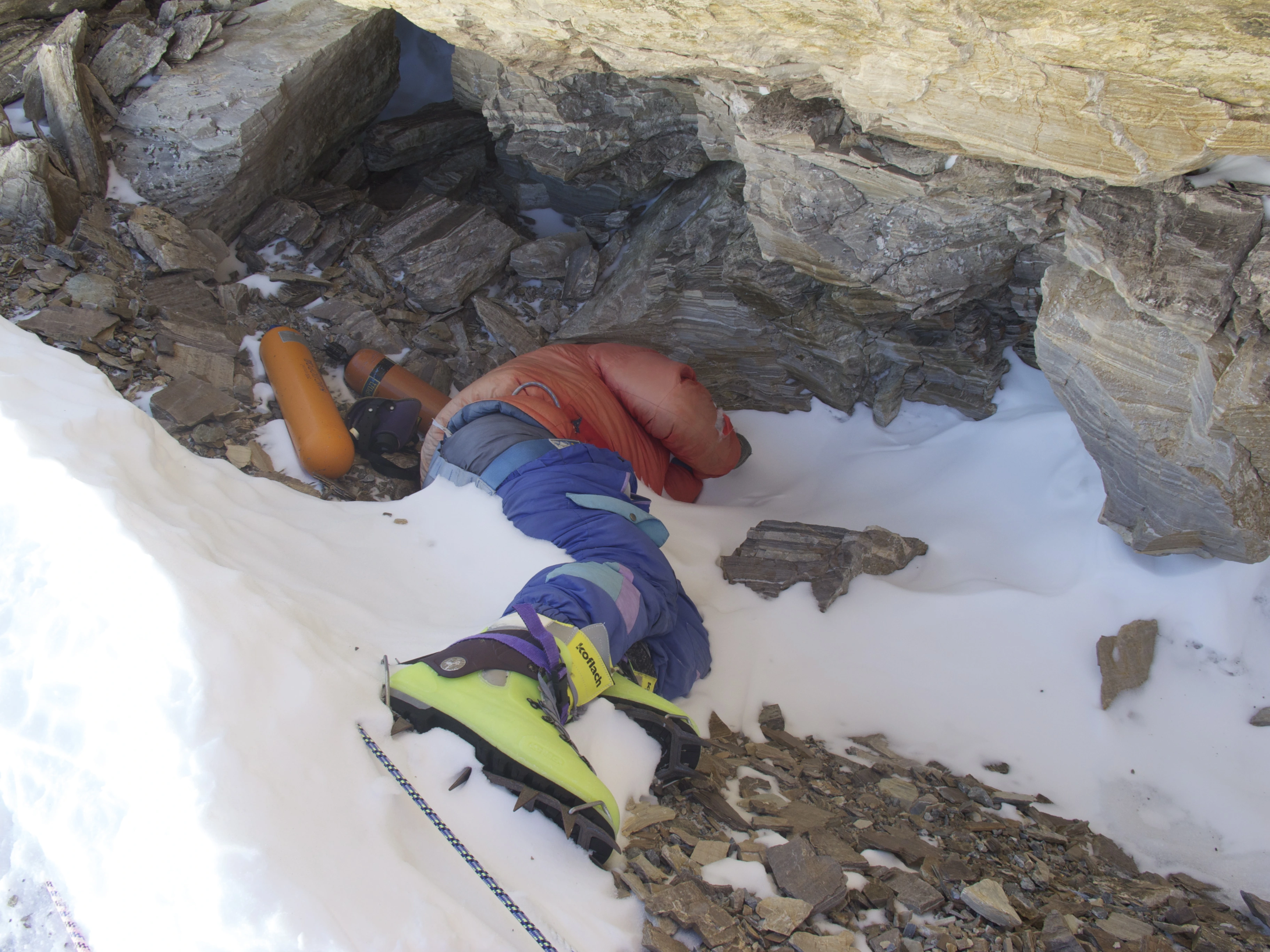
Green Boots Mt Everest is believed to be the body of Tsewang Paljor, an Indian climber who died on climbing Mount Everest disaster in 1996. The body is known as “Green Boots” because Paljor was wearing green Koflach mountaineering boots. The body of Tsewang Paljor, also known as “Green Boots on Mount Everest”, is still on Everest because it was moved to a snow burial site on the mountain’s slope.
Green Boots Mt Everest-A Tragic Story of Climbers of Everest.
Keynotes of about Green Boots Mt Everest
The body of Tsewang Paljor was found in a cave on the Northeast Ridge of Mount Everest in 1996. The body became a landmark for climbers on the Northeast Ridge route. In 2014, the body was moved to a snow burial site on the mountain’s slope. In 2017, mountaineers found the body again and covered it with snow. The body is still on Everest and is easily recognizable by climbers.
Green Boots Mt Everest Facts
Tsewang Paljor was an Indian member of the Indo-Tibetan Border Police expedition (ITBP). He died in the 1996 climbing disaster on Mount Everest. The 1996 Everest tragedy was one of the deadliest historical disasters with eight climbers dying. The tragedy led to a radical transformation in the way excursions are made at the world’s highest peak.
Green Boots Mt Everest is the body of an unknown climber, found on the north east ridge of Mount Everest. The green Koflach mountaineering boots on his feet are the term “Green Boots” first seen. Up until it was moved in 2014, all excursions from the north side discovered the body curled in the limestone alcove cave at 8,500 meters (27,900 feet). Nearly every climber who ascends the top encounters this enigmatic corpse known as Green Boots Everest.
A Tragic Story of Green Boots Mt Everest
British climber and filmmaker Matt Dickinson captured the first known video footage on Green Boots in May 1996. The video was used in the 1996 Brian blessed film Summit Fever. The unnamed climber is identified as being from Nepal by the film’s narrative. The body gained notoriety over time for its location on the north route as well as its connection to David Sharp’s passing. Members of a Chinese expedition moved Green Boots in 2014 to a less obvious site.
Years later, his body was discovered on the peak’s northern crest, or at least that is what the search team believed when they discovered it. In actuality, the body had been lying there eerily for so many years and had a pair of green boots on it. The body had been given the moniker Green Boots Everest because of the color of the boots. Many people still today hold that Paljor is the rightful owner of the body, while other beliefs contend that this is not the case.
Green Boots Mt Everest, Found in 2001
First time, Green Boots were found on Mount Everest in 2001. The Sherpas at the time thought that the body belonged to a Chinese mountaineer who had passed away around six months prior. Later, it was discovered that the body belonged to a person who had passed away in 1996, on the Everest disaster, an avalanche that killed the lives of eight climbers, climbing Mount Everest. It was rumored that Tsewang Paljor, who was a member of the first Indian expedition team, attempt to climb Everest, was in reality the Green Boots in Everest.
In 1996, an Indian climber by the name of Tsewang Paljor became disoriented while attempting to scale the Everest. The 28-year-old Tsewang Paljor, an Indo-Tibetan climber from Sakti, a small mountain town in North India. He had the confidence to realize his aim of becoming the first Indian to climb Mount Everest from the North Side because he was a border officer who had grown up in the Himalayas.
Due to his history in climbing and job as a border police in the high altitude of the border between India and China, Paljor was confident that Everest was not a serious problem. Along with reaching the summit, his goal was to become the first Indian to climb Everest from the North Side. Despite being informed that the weather is getting worse, Paljor and two of his co-workers decide to press on rather than give up.
Although several Indian teams had before scaled the mountain, the six-person Indian team was the first to try the ascent from the eastern ridge. The Indian Indo-Tibetan Border Police (ITBP) expedition sent the climbers on the northeast route. It was the first Indian ascent of Everest from the east side, and Commandant Mohinder Singh oversaw the trip. Harbhajan Singh, the sole survivor of the Indian mountaineering expedition, was unable to reach the peak of Mount Everest due to weather conditions, which he stated were worsening.
Green Boots Mt Everest Of Tsewang Paljor
Paljor died away at the age of 28. On May 10, 1996, just below the top, Subedar Tsewang Smanla, Lance Naik Dorje Morup, and Head Constable Tsewang Paljor were stuck in a blizzard. The storm appeared to be lethal, so three of the six people made the decision to head back. The other three, including Paljor, were more resilient and made the decision to press on and reach the summit however they could. Smanla, Morup, and Paljor made the decision to attempt the summit. The three climbers radio messaged their expedition leader at 15:45 Nepal time to let him know they had reached the summit.
They left a gift of khatas, pitons, and prayer flags. The leader Smanla made the decision to spend more time here for religious ceremonies and gave the other two instructions to descend. After that, there was no further radio contact. Team members who were still in the camps below noticed two head lights moving just above the second step, which is located at 8,570 meters (28,117 feet). None of the three were able to return to high camp, which is located at 8,300 meters (27,231 feet). The condition that led to their death is unknown due to the poor weather.
Later, there was debate over whether or not and a group of Japanese climbers from Fukuoka had seen the missing Indian climbers and maybe neglected to save them. At 06:15 Beijing time, the group left their camp at an elevation of 8,300 meters (27,231 feet), and they arrived at the summit at 15:07. They came across other climbers on the trail along the way.
They thought these others, all of whom had goggles and breathing masks under their hoods, were members of a climbing party from Taiwan, unaware of the missing Indians. They started their descent at 15:30 and claimed to have seen an unknown object above the Second Step. They did radio message to report spotting one person on a fixed rope below the first step.
Shigekawa, one of the climbers, then greeted an unidentified man who was standing close. They only had enough oxygen at that point to get back to C6. The Fukuoka party learned that three men were missing from an Indian in their group at 16:00. They proposed to assist with the rescue, but it was turned down. They had to wait until May 13 to send a second party to the summit due to severe weather. Although they came upon many bodies at the First Step, they kept going to the peak.
Regarding the acts of the Fukuoka team, there were first some misunderstandings and harsh words, which were subsequently rectified. The Indian team allegedly stated that the Japanese had promised to assist with the search but had instead moved forward with their summit attempt, according to Reuters.
The Indian-Tibetan Border Police accepted the Japanese team’s denial that they had abandoned and refused to assist the climbers who were near death while ascending. Captain Kohli, a representative of the Indian Mountaineering Federation, eventually withdrew his prior criticism of the Japanese and acknowledged that the Japanese had not met the Indians on May 10.
While it is generally accepted that Green Boots contains the remains of Head Constable Tsewang Paljor, a 1997 article titled “The Indian Ascent of Qomolangma by the North Ridge” written by the expedition’s deputy leader P. M. Das in the Himalayan Journal suggests that Lance Naik Dorje Morup, aka Dorje, might actually be the person buried there. At 19:30, two climbers were sighted descending by the light of their headlamps, according to Das, however they quickly disappeared from view.
The expedition’s second summit group’s leader radioed base camp the following day to report that they had seen Morup moving slowly between the First and Second Steps. Das stated that Morup “had refused to put on gloves over his frost-bitten hands” as well as “was finding difficulty in unclipping his safety carabineer at anchor points.” Das claims that the Japanese team helped him move to the following rope stretch. The body of Tsewang Smanla was later found by the Japanese team above the Second Step.
Morup was still making slow progress as the gang arrived back at their starting point. On May 11, in the late afternoon, Morup is thought to have passed away. According to Das, Paljor’s corpse was never discovered. Smanla and Morup’s bodies were also discovered by a second ITBP team while they were leaving the top. Morup was found by them “lying under the shelter of a boulder near their line of descent, close to Camp 6” with his bag by his side and all of his clothing in situ, according to Das.
By the beginning of the twenty-first century, Green Boots joined the group of about 200 bodies that were still on Everest. When the phrase “Green Boots” first appeared in Everest slang is unknown. As all the excursions from the north side ran into the climber’s body curled up in the limestone alcove cave over time, the phrase eventually spread. At a depth of 27,890 feet (8,500 meters), the cave is covered in empty oxygen tanks. It is down the way from the first step.
Francys Arsentiev, who perished in 1998 after attempting an unsuccessful descent from Everest after summiting, is another climber who has failed and earned the moniker “Sleeping Beauty”. She died where she fell, and her body was on display until 2007, when it was formally hidden.
In “Rainbow Valley,” a region below the summit where bodies covered in vividly colored mountaineering gear are scattered, there are further bodies. Hannelore Schmatz, known as “the German woman” because her prominent placement on the south path, is yet another identified corpse. She reached the summit in 1979 but passed away while descending at an altitude of 8,200 meters (27,000 feet). She stayed there for a long time before being blown further down the mountain.
Climber Mark Inglis and his group discovered British mountaineer David Sharp in a hypothermic condition in Green Boots’ Cave in 2006. After radioing for assistance in helping Sharp, which he was unable to give, Inglis continued his ascent. A few hours later, Sharp passed away from intense cold. On that day, some thirty other climbers would have passed the dying guy; it has been conjectured that those who saw him thought Sharp was Green Boots and gave him no mind.
Green Boots is starting to take on the unmistakable significance of Everest’s inherent dangers. For climbers who have their sights set on the highest peak in the world, the figure known as Green Boots serves as a somber reminder. The chilling sight of his ultimate resting place brings home to us the severe conditions of the mountain. He vividly described the possible repercussions of being unprepared.
For more than 25 years, Green Boots, who is thought to be Tsewang Paljor, has left his silent warning in the history of mountaineering. His experience is not unique; the mountain’s harsh terrain has claimed the lives of over 200 climbers. Their carcasses are uncannily preserved in the high-altitude “death zone.”
Many of these fallen climbers go unharmed because of the costly, risky, and challenging process of recovering them. They were unintentionally creating a high-altitude cemetery on Everest. Within the climbing community, this phenomena has sparked discussions. In essence, it discusses the validity of leaving these bodies where they are from an ethical standpoint. It has prompted demands for modifications in how Everest’s fallen are handled.
Despite the assertions made by several parties, it is impossible to point the precise identity of Green Boots in Everest. The corpse of Green Boots Everest was reported missing from its original location in the year 2014. They had begun to think that the body had most likely been buried beneath the snow. A body was later discovered hanging on the cliff in 2017. Many people believed that the body was Green Boots Everest, moved here from its original location on the ridge. But generally, it was difficult to be certain.
Further Answer and Questions(FAQS)
Is Green Boots still on Mount Everest?
Green Boots is among the roughly 200 corpses remaining on Everest by the early 21st century. It is unknown when the term “Green Boots” entered Everest parlance. Over the years, it became a common term, as all the expeditions from the north side encountered the climber’s body curled up in the limestone alcove cave. The body of “Green Boots, is still on Mount Everest in 2024. While there were reports in 2014 that the body was no longer visible, it was later confirmed to be present again in 2017, with more rocks surrounding it.
What is the identity of Green Boots Everest?
The Green Boots in Everest is the dead body of a climber on the Northeast Ridge route believed to be Tsewang Paljor. He was an Indian climber and Indo-Tibetan Border Police officer. The infamous name came from the green mountaineering boots he wore.
How cold is the death zone on Mount Everest?
Above 8000 meters, considered the death zone of Everest at the summit the temperature fall is recorded to be -60˚C. This temperature of Everest is resulted due to excessive high altitude and low air pressure making the air very thin to breathe properly.
What is Rainbow Valley Everest?
Rainbow Valley exists as a dark side of Everest despite being commonly known by its name. Rainbow Valley stands as a morbid memorial to all those who perished within the lethal area of the mountain. The frozen clothes of dead climbers stay in the area for a long time. This is why the place is called Rainbow Valley.
What is the death zone on Mount Everest?
The altitude above 8,000 meters (26,247 feet) consider the “death zone” on Mount Everest where the oxygen level is so low that humans cannot survive for extended periods without supplemental oxygen. This area is known for its extreme conditions and high mortality rate.
Characteristics of Death Zone on Mount Everest
Low Oxygen-At this altitude, the atmospheric pressure is significantly lower, resulting in a much reduced oxygen level.
Extreme Conditions-The death zone is characterized by frigid temperatures, strong winds, and the physical and psychological toll of the extreme altitude.
Physiological Challenges-The body struggles to adjust to the low oxygen levels, leading to conditions like high altitude pulmonary edema (HAPE) and high altitude cerebral edema (HACE).
Risk of Death-Prolonged exposure to the death zone without supplementary oxygen can result in death due to organ failure or other complications.
Consequences for Climbers
Physical Strain-The physical exertion of climbing in the death zone, combined with the low oxygen, puts a tremendous strain on the body.
Cognitive Impairment-Low oxygen levels can impair cognitive function, leading to poor decision-making and increased risk of accidents.
Psychological Effects-The isolation, stress, and fear of the death zone can take a toll on climbers’ mental state.
Limited Time to Acclimatize-While climbers can acclimatize to some degree, complete acclimatization to death-zone altitudes is impossible.
Summits in the Death Zone-The summit of Mount Everest, and other “eight-thousand” peaks, lie within the death zone.
Use of Supplemental Oxygen-Most climbers use supplemental oxygen above 8,000 meters to mitigate the effects of the low oxygen levels.
Strategic Timing-Climbing expeditions often plan their summit attempts during favorable weather windows to minimize exposure to the death zone.
Risk Mitigation-Climbers must take various precautions, including proper acclimatization, careful planning, and adherence to safety protocols, to reduce the risk of injury or death in the death zone.
Yaks in the Himalayas are a crucial part of life in the Himalayas, serving as a vital resource for food, transportation, and even fuel. Yaks are also of significant cultural and religious importance in Tibetan Buddhist and Hindu traditions. They provide milk, meat, and hair, which is used for clothing, tents, and other items.
Yaks are used to carry goods, valuables, and even household items. Some farmers use them for ploughing fields, and others use them as riding animals. In areas with few trees, yak dung is a primary source of fuel for heating and cooking. You will find yaks in Langtang, Everest, Annapurna Circuit, Dolpo and Kanchenjunga trekking trail of Nepal.
Yaks in the Himalayas of Nepal.
Yaks are associated with religious traditions in Tibetan Buddhism and Hinduism. In Tibetan Buddhism, they are often depicted in religious art and are seen as symbols of abundance and prosperity. In Hinduism, the ceremonial fly whisk is made from yak tails.
Yaks are uniquely adapted to the harsh high-altitude environment, with thick fur and the ability to thrive on the sparse vegetation found in those areas. Yak herding is a way of life for many people in the Himalayas, deeply intertwined with their identity, traditions, and resilience.
Yaks are high-altitude Himalayas mammals with long hairs and horns that can survive in cold places and mostly higher elevations on earth. The yaks ascend to around 6,100 m due to their disease susceptibility and thick coats, yaks prefer to dwell at high altitudes. Yaks can’t survive below 10,000 feet above sea level regularly.
Yaks often have huge lungs because they need more oxygen at higher elevations. Yaks can weigh as much as 550 kg. The males of the species are typically referred to as “Yak” and the females as “Nak”(Dzopkyo) by the Sherpas of Nepal. However, “Yak” refers to the entire species as outsiders.
Yaks have made it feasible for the renowned Trans-Himalayan trade route between Nepal and Tibet to exist. One yak can travel across treacherous paths and snow-covered high Himalayan passes while carrying up to 100 kg of cargo.
Yaks are used as beasts of burden and to plow fields, provide meat, milk, and butter, as well as wool for clothing and dung for fuel. They are utilized to manufacture a variety of objects from their bones. Yak hair creates tents, sacks, ropes, and blankets. Nothing goes to waste; the horns are used to decorate roofs and doorways.
The fresh blood of a yak is frequently used as medicine by locals in the isolated mountains. They think that blood can treat a variety of illnesses. As a result, people travel to the pastures twice a year to drink fresh yak blood that has just been drawn. One glass of blood costs them roughly $1. Yaks are portrayed as the high-altitude gods’ messengers in Tibetan mythology.
Yaks and cows are hybridized. The male and female hybrid progenies are dzo and dzomo (female). They are easier to manage than yaks and can survive at lower elevations.
Domestic Yaks Information and Facts
Domestic Yaks raised for domestication tend to be smaller; males typically weigh 600–1,100 pounds, while females weigh between 400–600 pounds. Male wildlife can weigh up to 2,200 pounds. Domestic males can reach a maximum height of 44 to 54 inches at the withers, while females can reach a maximum height of 41 to 46 inches at the withers. Females have a tiny, hairy udder, along with four teats.
The male scrotum is comparable in this regard. The large size and hairy coatings provide insulation from the cold. Domestic yaks can have a variety of coat colors, including black, white, brown, and pied. They could have white, grey, and brown spots or speckles and be grey, black, or brown. Domestic yaks have shorter faces than wild yaks, but they have skinnier narrower foreheads.
About Wild Yaks in the world
The wild yak is found in herds of up to 300 animals, mostly made up of females and their young and only a few males. Before the mating season, most males live alone or in smaller bachelor groups of around six. At that point, they usually rejoin the more fabulous herd. However, they can turn hostile while protecting the young or during ruts, when males frequently fight among themselves to maintain supremacy.
They typically avoid people and may flee. Non-violent displays and aggressive actions like bellowing and horn-scraping are also standard during ruts. Bulls will continually attack one another while keeping their heads down or engaging in horn combat.
During the channel, males frequently wallow in dry soil and scent-mark with feces or urine. Wild yaks normally have very little color variation in their coats. The majority of their coats vary in color from jet black to dark reddish brown to dark brown.
Then there was the rare instance of the wild yak with the golden-brown coat. Wild Yaks have short, broad, and convex foreheads. Its forehead is bigger than the domestic yak’s, although its head is not as long.
Characteristics of Yaks
At its withers, the domestic yak is a huge animal that can weigh more than 1,000 pounds and stand between 3.5 and 4.5 feet tall. Yaks are large animals with broad foreheads and nostrils. Yaks have real horns, just like all bovids.
A yak’s horns project upward and laterally from the top of the animal’s head. While horns are constructed of a boney interior structure coated by a keratinous covering and are retained throughout life, antlers are made of bone and shed annually.
The yak’s coat can be any combination of white, black, brown, or these hues. It usually has long, skirt-like fur around the ventral torso and legs, and a shorter top. The yak’s tail is made up of long hairs, just like a horse’s tail is. This contrasts with the bottoms of cows and bison, which only have a tuft of lengthy hair at the end.
Bovids are even-toed ungulates, which means that each of their two toes is visible as a split in the middle of the hoof. In contrast, horses, zebras, and other odd-toed ungulates have one or three toes (such as rhinos). Yaks are incredibly sure-footed, especially when carrying huge loads down rocky, narrow paths. They stride boldly up mountain roads with a fall of a thousand meters and through raging streams.
Yaks are social animals that prefer to live in herds. They are prone to panic. When one yak waves of panic frequently, the herd does the same. Sometimes, herders purposefully scare the yak in the lead so that it will clear the path and behave as a snow plow.
Yaks typically sleep while standing. They can feed near the ground thanks to their large nose and square tongue. They are more adept than other animals at digging for grass beneath cold snow. Some yaks spend so much time grazing alone that they develop semi-wild characteristics.
Uses of Yaks in the Himalayas
In the Himalayas, yaks are undoubtedly the most significant species of mammal. They supply food and hair that can be used to make tents, garments, and other items, as well as carry goods, valuables, and household items. Some farmers use yaks to plow their fields, and some nomads travel on their steeds. In a place with no trees, yak dung is used to start fires (many Tibetan houses have piles of drying yak dung next to the walls).
Fabric is made from the hump hair and undercoat. Capes, jackets, and hats are constructed from the skin with hair. Boots and bottoms can be made of thick leather thanks to the thick hide. Eaten is yak meat. Butter from yak milk is used to make tea, light lamps, and make cheese and other dairy products (See Below). Yak skin is even used for boats in Lhasa.
The coarse belly hair is spun into ropes, turned into tent covering, and woven into blankets and other items. Yak hair rope with black and white braiding is quite expensive. One nomad explained to National Geographic why he preferred his yak wool tent to a house, “If the yaks are in distress, you can hear them at night from within a tent. And during the day, everything is visible. It’s too dark in a house.”
Herders make a consistent living by selling yak fur and hair. The plush undercoat is spun into “Chara,” a type of felt used to manufacture purses, blankets, and sweaters made of “yak cashmere.” Tibetan medicine makes use of the yak heart. Bones can be used to make glue. Yak tails’ white tips were removed and used as decorative tassels by the Chinese. The tails are employed as flyswatters in India.
Yak hair is used to create the wigs worn by Bunraku puppets in Japan. In the United States, yak hair was frequently utilized for Santa Claus beards in the 1950s. There is yak cashmere. Once a year, a yak race takes place in Qinghai. The yaks don’t run; instead, they stop along the road to munch grass, which slows down the race.
Products of Yaks in the Himalayas
The yak provides for almost all of the needs of the ranchers and their families. Yaks produce milk, hair and down, draught power, and manure for fuel during their lives. After slaughter, they have meat and various goods from their organs, non-consumable body parts, and hide. The herders and their families use the majority of these items. However, some are also marketed. Most articles can generate income, as can the sales of pack animals and animals for breeding.
Yak production is financially beneficial when yak herds are close to hill towns and villages since there is a quick market for the goods. Currently, most goods sold by the yak are primary or nearly primary goods. Thus, the economy based on the yak needs to reap the benefits of processing or producing more complex goods.
Butter and different kinds of soft cheese, which the herders make, are sold or bartered for other essentials. In some cases, as in some regions of India (Chapter 11, part 3), they are used to pay grazing field rent. The beginnings of advances aimed at opening up new markets for pastoral people may be seen in factories constructed in China and Nepal for the production of yak leather items and textiles, as well as factories erected in Nepal for the production of hard cheese made in the Swiss style.
These changes result from national efforts to improve the quality of life for those who live in these isolated mountain regions and boost the local economies. We briefly explain their history and, for the most part, contemporary uses. What follows is generally applicable to areas of China that produce yak. However, yak herders in most places likely use the same traditional techniques for creating and utilizing yak products.
Milk Products of Yaks in the Himalayas
Despite the low milk production of individual yak females, there are a large number of them. Therefore, a significant amount of milk is produced overall. Milk is typically consumed in sections of the nation where yak is most prevalent and in areas with alpine pastures.
Outside the main territory, in areas where yak have just recently been brought, there is no tradition of using milk from yak or hybrid offspring produced by mating yak males with local cattle females. These “local” hybrids have only a tiny amount of milk and are primarily utilized for draught (as distinct from the combinations of “improved” dairy breeds of cattle and yak cows).
Yak milk is now highly valued in China and, as a result, makes up a significant portion of the herders’ revenue.
Raw Milk
Whole milk is typically consumed by the sick or frail, though it is also given to young children and the elderly. Some of this milk is consumed raw since it is thought to be more nutrient-dense that way, but most of it is boiled first because it is advised for health and hygiene reasons. According to the findings, yak milk output has a high solids content of roughly 18%, including about 7% fat. Since whole milk tastes relatively sweet even without adding sugar and has a pleasant, sweet-smelling aroma, herdsmen never add sugar when drinking it.
The beverage known as “milk tea,” a concoction of tea and milk, is mainly made with raw milk and is consumed throughout the year. The shepherds and their families consume this frequently. The beverage is yellow and contains 20% or more milk during the warm months when plenty of milk is available or when served to guests.
The light tea that herders and their families choose to consume contains only 5% milk, making it milky white with a hint of yellow. The Milk tea is made by steeping tea leaves (cut from a tea brick) in water and boiling it for a little while. Then, the needed amount of raw milk is added, and the boiling process is repeated for a short time. Some folks might salt the food a little. Although no sugar is ever added, milk has a mildly sweet flavor. The main dish in Tibet is Zumba (also known as tsampa).
It is typically formed into balls for eating and is produced from roasted oat, barley, or a combination of the two flours. Tibetans may add some Zumba to the brew for themselves and their guests to make it both a snack and a beverage. Herders consider milk that has been boiled with mushrooms to be a delicacy.
The milk-mushroom stew typically contains salt, and boiling is supposed to protect from poisoning if the incorrect mushrooms have been used. Although skimmed milk is also used in place of whole milk to enhance the amount of butter made from the milk supply, whole milk is often used to make tea. In pastoral areas, it is customary to utilize raw milk to raise small yak calves, lambs, or children who have lost their moms or are unable to adequately suckle milk from frail mothers. Sometimes, in addition to meat, pets like cats and dogs are provided access to yak milk. Additionally, raw milk is sold to factories that make milk powder, butter, and other milk products.
These factories were recently erected. In towns and villages, some milk is sold for immediate consumption. In highland areas, it can be bartered for food grains.
Butter
The main byproduct of yak milk is butter, a staple sustenance for the local population. Additionally, it is the leading milk product sold by herders. The percentages of water, protein, and fat in raw butter range from 12 to 15%. (About 3 percent of old butter is water.) Herders pay close attention to butter production since it is thought to be a good indicator of the caliber of yak milk.
Yak butter is often made in China using one of two methods. The butter is either pressed in a hide bag or traditionally churned in a wooden bucket, which is still the most common process.
In some places, milk separators are in use, which lessens the labor-intensiveness of making butter. The best butter is made from cream that has been separated in this way before being churned since it has lower water content and longer shelf life. Butter is a common ingredient in many cuisines, including Zumba, pancakes, and fried items.
Additionally, depending on the region, it is put into milk tea and eaten salted or unsalted. In some places, butter is used for raw milk in tea when it is unavailable. Some people reportedly prefer butter, especially herders in the pastoral regions of Tibet and Northwest Sichuan.
Melted butter and toasted flour can also be combined in equal parts. Once kneaded, the mixture is kept till use. When necessary, this dough is either blended with nuts like peanut, sesame, walnut, soybean, or Chinese dates or melted into salted or sugared water and eaten that way. These components flavor the cuisine and make it a favorite among Tibetans when serving visitors.
Yaks in the Himalayas Dog Chew-Chhurpi
Nepal was one of the first nations in Asia to develop a cheese business, and up until the 1980s, it was the only nation in the world making yak cheese. It has been more than 40 years since the yak cheese industry in Nepal was established.
The milk of Nak (a female yak) and Chauri (a female hybrid) is currently used to make hard Gruyere cheese in the Swiss manner. Yak cheese production is now being attempted in Bhutan, Mongolia, India, and Pakistan.
Yak Chhurpi
Yak milk mainly makes Churpi (a hard, dried cheese). Churpi made from skim milk is prepared and stored in untanned bags. Outside of herding communities, these items have no commercial value.
Milk cake
Although skimmed milk is occasionally used, whole milk makes up most of this product. It produces something like “milk residue,” but it is firmer and has a cake-like appearance. It is one of the dishes served to guests and is typically eaten with butter and sugar, which the herders find to make it even tastier.
Whey
In pastoral areas, whey is mainly used to make cheese, butter, and buttermilk residue. However, in agricultural and rural settings, pigs can be fed with it. The traditional method of manufacturing leather also uses whey.
Sour milk
During the year, but particularly during the warm season when milk is produced in significant quantities, sour milk is a favorite among herders and their families. A pail is filled with freshly boiled milk, which is then combined with a small amount of sour milk until the temperature drops to 40°C at 50°C. Then, to keep the pail warm, it is covered and wrapped with wool.
The milk will have soured five or six hours later during the summer season and longer throughout the winter. Skimmed or whole milk can be used to make this product; the former has a richer flavor and color.
Meat and Meat Products
The meat of the yak is a valuable source of protein for the herders and their families, but it is also sold. The heart is consumed even in places and nations where religious taboos prohibit animal slaughter, but professional butchers, not the animals’ owners, perform the killing. Every year, many yaks are killed, usually right before the start of winter when they are at their healthiest.
While much of the meat is frozen in nature’s “deep freeze” and stored that way, some of it is consumed fresh. Additionally, dried meat keeps longer than frozen beef.
Although a few yaks may die or be killed. The herders and their families consume meat for four to five months after a sheep is slaughtered. As a result, yak is not intentionally destroyed in the spring or early summer because they are in poor health and very lean at that time. Therefore, herders rarely consume meat from April through July, though dried yak meat is still accessible.
Himalayan Fresh Yak Meat
Yak “beef” is of the highest grade in the autumn because the animals were in excellent health then. The herdsman’s procedure of butchering and eating is pretty straightforward. The carcass is divided into large cubes and briefly cooked in fresh water.
The supper is more lavish when guests are present: Both sheep and yak rib meat that has been boiled is presented; it is put on a platter and eaten with the hand.
Using a Tibetan knife and salt, the heart is consumed. At the same time, milk tea is consumed. A steamed bun with chopped yak meat may have been seasoned with salt, sauces, and grease. Because the flour combination has not been fermented, the bun’s casing is thin. Yak meat from frozen, defrosted packages tastes identical to fresh.
Air-Dried Meat
Before winter, the upland ranchers slice yak meat into 30 cm-long, narrow strips roughly 4 to 5 cm wide and hang it to dry from ropes made of woven hair. It only takes a few days to dry. The meat that has been air-dried will last for one or two years if it is hung in a tent or kept in hiding bags; this is a longer storage time than the meat that has been naturally frozen.
The meat is quite dry and flavorful after being air-dried. Some dried meat is consumed whole, except by ripping or cutting the strips into smaller pieces. Milk tea is consumed in addition. There are two primary ways to prepare dried meat. One method is to roast it by burying the meat in a yak dung-fueled stove until the meat begins to smell good. Then it is removed, cleaned, and divided into bits. The other approach involves soaking the dried beef for several hours before boiling it. Typically, salt and condiments are not added.
Smoked Meat
In contrast to air-dried beef, smoked “bacon-beef” is made from fresh meat strips that are first salted for one or two days in a container before being smoked over the stove in the herdsman’s tent.
Once more, you may eat this either raw or cooked. The flesh used to make the smoked meat is taken from yak that has died of old age, sickness or were murdered by wolves. It is produced throughout the warm and wet seasons.
Corned Beef
Salted “bacon beef,” sometimes known as corned beef, is a delicacy in the yak-farming regions of Yunnan province, China. Meat strips from frozen are massaged for one to two minutes. Salt and other seasonings are added once the meat has softened. The meat is rubbed until it is moist, at which point it is placed in a jar and covered with paper or cloth to seal it.
The salted meat is removed from the pot after 18 to 21 days and allowed to air dry for roughly seven days. The most excellent corned beef is reddish in color, savory, and delicious. It can be served with Zanba and milk tea after being boiled, steamed, or fried.
Sausage
Blood and meat are the two primary varieties of sausage stuffing. The yak’s cleansed big or small intestine is used as the casing for the sausages. When the yak is killed, sausage is created, especially the blood sausage.
Leather
The leather from yaks is mainly used to make shoes and boots but also to make bags, belts, and saddles for horses. Although the yak possesses thick grease deposits in the skin’s layers that help the animal survive in the frigid Himalayan climate, manufacturing yak leather is difficult.
Yak leather has a denser fiber structure than regular cow leather because of the unfavorable life conditions (cold, wind, snow) that Tibetan animals must endure. As a result, yak leather must only be half as thick to be as robust and heat-insulating as bovine leather. Because of the more significant production costs, as a result, good yak leather is costly leather. Age and gender are other factors that affect the leather’s quality.
The fibers are thicker, coarser, and more irregular with age (much like in cattle). However, as the skin becomes uneven and fibrous in deeper layers, this is a pretty ugly situation for the leather quality. China is the biggest exporter of yak leather. The hides can come straight from the nomads or from slaughterhouses. Yak skin ranges in size from 2.5 to 4 square meters. Comparatively, a cow’s skin is around 5 square meters.
Wool
Yak wool is a gorgeous long fiber that typically has a diameter in the 18-micron range, making it incredibly soft and firm. All things being equal, it will last longer even though you give up a little softness compared to cashmere.
Yak wool, like the majority of natural wools, is prized for its ability to wick away moisture and regulate body temperature. Due to the unique mix of these qualities, it is used in various high-end performance equipment. Three natural hues of yak wool are available: platinum grey, dark chocolate, and light milk chocolate.
these colors will vary slightly from year to year and batch to batch because they merely blend the tints closest to the goal color. For instance, if your yak is white, its wool will fall within platinum grey. A yak could end up with either hue if it is between two shades of brown.
Surprisingly, the colors appear uniform, albeit the grey shows a little more mélange. As yak wool is more difficult to dye than other fibers like cashmere and sheep’s wool, it is typically exclusively marketed in natural colors.
Mountain Adaptations Yaks live in high-altitude regions, especially the abrasive Himalayan mountains. While many animals would not be able to survive in these climatic conditions, years of evolution have helped this bovid become a creature that prevails in an otherwise tricky environment by strengthening its resistance to freezing temperatures and preventing low oxygen levels.
Temperature Adaptations Himalayan yaks are adapted to frigid climates and can endure periods of -40 degrees Fahrenheit because of their exceptionally thick coats, which are good at holding heat. Yaks don’t get much from evaporative cooling since they don’t have enough sweat glands, and their fur traps too much heat.
Yaks may suffer in somewhat warm situations because of their exceptional ability to insulate and survive cold temperatures. Managers who keep these animals as livestock may relocate their herds to higher elevations during the warmer months to keep the animals from suffering heat stroke.
Oxygen Adaptations Overcoming the thin atmospheric conditions that might result in low oxygen levels in the body is one of the biggest challenges of living at high elevations. Yaks have larger lungs and blood rich in red blood cells and hemoglobin to make up for this. With each breath, the lungs can be expanded to accommodate more air, and the body can carry oxygen more effectively, thanks to an increase in hemoglobin and red blood cells.
Facts of Yaks in the Himalayas
Although a small, fragile wild yak population remains, most yaks are domesticated.
Animals that herd is yaks. Herds can number in the hundreds, though they are frequently much less.
With a decreased proportion of adult males, the herds mainly consist of females and their young.
They spend a lot of time grazing on mountain plains, where they consume grass, herbs, and wildflowers.
Yaks are the only mammals to live at such a high elevation.
Like other cow species, the yak has several stomachs, which it uses to extract all the nutrients from the vegetation it eats efficiently.
Yaks can break through snow to reach vegetation buried beneath it because of their complex, big horns. They’ll also defend themselves by using their horns.
They have a thick undercoat protected by outer hair that almost reaches the ground and is often dark brown to black.
A yak can endure winter temperatures as low as -40 degrees Celsius (-40 degrees F).
They will bundle up with their calves in the warmer center throughout the night and during snowstorms to avoid becoming too chilly.
In June, yaks typically give birth. Every other year, a female yak gives birth to a single calf. The mother will look for a remote location to offer delivery. The calf can walk within 10 minutes of being born, and the pair will re-join the herd.
Although moms can be very protective of their young and can bluff charge if they feel threatened, yaks are generally very friendly, and there hasn’t been much recorded hostility from yaks against humans.
Contrary to popular opinion, when properly cared for in pastures or paddocks with sufficient access to fodder and water, yaks and their dung have little to no discernible smell.
Yaks grunt and are not known to make the distinctive lowing (mooing) sound that cattle do.
The Tibetan Wolf has traditionally been the primary natural predator of the wild yak; however, in some regions, reports of Brown Bears and Snow Leopards preying on Yak have also been made.
The destruction of their habitat and excessive human poaching put wild yak in danger.
Down is the term used to describe the undercoat that yaks naturally shed each winter. This one is one of the silkiest, softest, and warmest natural fibers. Compared to cashmere, which results in overgrazing, it is just as smooth and far more sustainable than cashmere, which results in overgrazing.
Yak down is incredibly rare and a sustainable, renewable fiber.
Each yak produces only approximately a kilogram (2.2 lbs) of fiber annually. A little German Angora rabbit could have nearly the same amount.
Yaks are quicker than they seem to be. Yaks are not only utilized as racehorses during traditional festivities in some cultures, but their wild counterparts are also very agile for such enormous animals.
Yak Lifespan, Babies, and Reproduction
Although females can go into estrus up to four times a year, mating usually occurs in the late summer or, depending on the local conditions, even into September. Between 257 and 270 days pass during gestation, and a single calf is born in May or June.
Twin births are uncommon. Females choose a remote area for delivery but immediately reunite with the herd because calves can usually walk within 10 minutes of labor. Most females only give birth every other year, yet, births may be more frequent if food is abundant.
Yaks for trekking in the Himalayas
The yak is a valuable companion when hiking through the Himalayas. You may load bags, tents, cameras, and other everyday needs on its back. The yak can traverse the plateau’s mountains. It makes sense that the yak merits the “boats on the plateau.”
Himalayan yaks serve as load-carrying animals in addition to being animals that assist with agriculture. When traveling in the Himalayas, they come in handy for hauling bulky goods and gear. Especially on Mount Kailash Kora and from Everest Base Camp to Advanced Camp, yaks are used for trekking.
How many yaks are left in the world? Only 10,000 wild yaks survive now, down from as many as a million just fifty years ago when they roamed the Tibetan plateau due to interbreeding with cows, habitat loss, and human-caused poaching.
Where do Yaks live? The alpine tundra, grasslands, and chilly desert parts of the Tibetan plateau are where the Yaks reside. These altitudes range from 4,000 to 6,100 meters.
Are yaks dangerous? Even though moms of yaks can be very protective of their young and can bluff charge if they feel threatened, yaks are generally pretty friendly animals, and there is very no evidence of their acting aggressively against humans.
What do yaks eat? Yaks graze on grasses, herbs, and lichens primarily in the morning and evening. They also consume ice and snow as a source of water. Wild yaks, however, must travel a great distance to find enough food because there isn’t much vegetation nearby where they live.
Yaks-good pets or bad? Yaks are valuable farm animals in their range, but they might not make suitable pets. Yaks are more prone to violence than domestic cattle and cannot survive in warmer climates.
What distinguishes the yak from the cow? Since “cow” refers to a female and not a particular species, a yak can be considered a cow. Yaks differ significantly from domestic cattle, though. Yaks can endure cold, high-altitude conditions that would be fatal to ordinary cattle thanks to a variety of adaptations (including long coats and larger lungs).
Hence, Langtang Valley, Annapurna Circuit and Mustang are some of the best places to see yaks in the Himalayas. Tibet Mount Kailash Mansarovar region are also a good travel destinations to view herds of yaks.
Learn how to trek to Everest Base Camp before you go.
Mount Everest has two base camps-the Everest South Base Camp is in Nepal at an altitude of 5,364 metres, while North Everest Base Camp is in Tibet at 5,150 metres. The base camps are rudimentary campsites at the base of Mount Everest that are used by mountain climbers during their ascent and descent. They are also visited by hikers. Everest South Base Camp is used when climbing via the southeast ridge, while the North Everest Base Camp is used when climbing via the northeast ridge.
Supply to the South Base Camp is carried by porters, and the yaks. The North Base Camp is accessed by a paved road. Climbers typically rest at base camp for several days for acclimatization, to reduce the risk of altitude sickness.
Nepal Everest Base Camp
The Everest Base Camp trek on the south side, at an elevation of 5,364 m is one of the most popular trekking routes in the Himalayas. About 40,000 people per year make the trek there from Lukla Airport (2,846 m). Trekkers usually fly from Kathmandu to Lukla to save time and energy before beginning the trek to the base camp. However, trekking to Lukla is possible. There are no roads from Kathmandu to Lukla and as a result, the only method of transporting large and heavy goods is by plane.
Everest Base Camp Trek Route
From Lukla, climbers trek upward to the Sherpa capital of Namche Bazaar, 3,440 metres (11,290 ft.), following the valley of the Dudh Kosi river. It takes about two days to reach the village, which is the central hub of the area. Typically at this point, climbers allow a day of rest for acclimatization. They then trek for another two days to Dingboche, 4,260 metres (13,980 ft.) before resting for another day for further acclimatization.
Most trekkers use the traditional trail via Tengboche monastery, but recently, the high trail via Mong La and Phortse has gained popularity due to the impressive views it offers. Another two days takes them to Everest Base Camp via Gorakshep, the flat field below Kala Patthar, 5,545 metres (18,192 ft) and Mt. Pumori.
Everest Base Camp Height(Elevation)
Everest Base Camp on the South side (Nepal) is located at an altitude of 5,364 meters (17,598 feet) above sea level. This base camp is on the Khumbu Glacier, a constantly moving glacier that can cause the location of the base camp to shift slightly year on year.
The youngest person visited Everest Base Camp
Zara, a four-year-old girl from the Czech Republic has made history by becoming the youngest ever person to reach Mount Everest base camp. She managed to make the 170-mile journey to base camp at an elevation of 17,598 feet.
Permits and Paperwork
As well as arranging a guide, trekkers need to register for a Trekkers’ Information Management System (TIMS) card, administered by the Trekking Agencies’ Association of Nepal (TAAN), purchase a Khumbu Rural Municipality permit (available in Lukla), and pay the entry fees for Sagarmatha National Park (available in Monjo or at the Tourist Service Center at Bhrikutimandap in Kathmandu). We take care of all your paperwork for trekking to Everest Base Camp.
Health and safety
Acute Mountain Sickness (AMS) is a risk on any trek above 2500m (8202ft). To give your body time to adjust, acclimatization days are essential, and guides will build these stops into the schedule. Some people start to feel the effects of altitude above 3000m (9800ft), and by 4000m (13,100ft), almost everyone will have an elevated heart rate, faster breathing, and maybe a headache and difficulty sleeping.
Some people adjust quickly to altitude, but others don’t. While everybody responds to altitude differently and there’s no guarantee a fit traveler will withstand altitude better than their out-of-shape friend, the overall experience tends to be easier if you’re fit and healthy.
Medications such as Diamox (Acetazolamide) are available in Kathmandu (or at home) to help reduce mild symptoms as you adjust to the altitude, but it’s important to be alert for more serious warning signs of AMS and other high-altitude illnesses. If you feel unwell, descend immediately to a lower elevation – mountain sickness can be deadly.
Everest Base Camp Height/Altitude
The base camp is 17,600 ft or 5,380m. However, you will probably also trek to Kala Patthar, which looks over the base camp. Kala Patthar is 5,644m high.
Everest Base Camp Trek Distance
The distance from Lukla the first town to Everest Base Camp is 38.58 miles or 62 kilometers. Most people take 8-9 days trekking to Everest Base Camp and 3-4 days trekking back to Lukla. It took 8 days to trek to Base camp and two days to trek out.
Everest Base Camp Temperature
During June when I trekked it was sunny in the days and I actually wore shorts every day. However as I mentioned above about when the best time to be trekking to Everest Base Camp is, it can get very cold at high elevations during November to January (-20 to-30)
Meals/Food on Everest Base Camp Trek
Meals on the Everest Base Camp trek offer a mix of local Nepali dishes and some Western options. You can expect to find traditional Nepali staples like Dal Bhat, Momo, and various vegetable dishes. Additionally, teahouses often serve Western dishes like pizza, pasta, and sandwiches, providing familiar flavors for those seeking variety.
Dal Bhat-A staple of the region, Dal Bhat consists of lentil soup (dal), rice (bhat), and various vegetable dishes (Tarkari). Meal prices vary depending on the location and teahouse, but you can generally expect to pay between $10-$15 per dish, potentially more at higher altitudes.
Everest Base Camp Trek-Accommodations
Accommodation during the Everest Base Camp trek typically involves staying in teahouses or lodges, offering simple but comfortable rooms with beds and blankets. These basic accommodations provide a unique trekking experience and are often family-run, offering a warm and welcoming atmosphere.
Teahouses and Lodges
Basic but Comfortable-Rooms usually have two single beds with mattresses, pillows, and blankets. Some lodges may offer better facilities like en-suite bathrooms and hot showers.
Shared Bathrooms-Bathrooms are typically shared, and toilets are often squat-type.
Communal Dining-Teahouses have spacious dining rooms where trekkers can enjoy meals and socialize.
Electricity and Wi-Fi-Most teahouses have electricity and Wi-Fi, though internet speeds can vary.
Hot Showers-Hot showers are available at many teahouses, often heated with solar or gas.
Social Hubs-Teahouses are known for being social hubs where trekkers can meet and share stories.
Local Hospitality-Stays at teahouses allow trekkers to experience local culture and hospitality.
Luxury Options-Luxury lodges with better facilities are also available for those who prefer more comfort.
Additional Considerations
Sleeping Bag-While teahouses provide blankets, it’s recommended to bring a warm sleeping bag for added warmth, especially at higher altitudes.
Shared Spaces-Teahouses are shared spaces, so be prepared for some noise and potential for sharing rooms.
Wifi and Electricity Availability on Everest Base Camp
Wifi-Costs anywhere from $3 to $10 to use wifi at the guesthouses. Buy a Ncell Sim before you go. Ncell works at 50% of the guesthouses.
Electricity-You will have to pay anywhere from $2 at low elevation to $8 at high elevation to charge your power banks, cameras, and phones. The key is to get a fat power bank. Pay to charge that then charge everything from your power bank. My power bank lets me charge my phone and four camera batteries before it would be done.
Everest Base Camp Package
Everest Base Camp Package Cost ranges from $1400 to $2500, depending on trip days and the services. In the package price, it includes flight, guide, permits, meals and accommodations.
Everest Base Camp Packing List
Keep in mind you won’t be doing any washing. Clothes that dry quickly and are lightweight are key. Here is a packing list for Everest Base Camp. All of this should fit into a backpack no bigger than 50L and be less than 15kg.
Clothes 2 pairs of pants that rip off into shorts 2 long sleeve quick-dry material shirts 5 Pairs of Thermal North Face socks 1 Fleece pants and sweater. 1 Thermal Lycra long sleeve and pants 5-6 pairs of quick-dry underwear 1 huge waterproof down jacket Beanie Neck Buff Gloves
Other gear Headlamp Water Purification pills and 1L bottle Sunblock Sunglasses Hat Watch Camera gear and electronics (Not necessary but up to you. Obviously I carried a lot) Power bank
Why trek to Everest Base Camp in Nepal?
Mt Everest straddles the Nepal-Tibet border, but when people talk about trekking to Everest Base Camp, they almost always mean the route in Nepal. As well as having excellent infrastructure for trekkers, Nepal is more open and accessible to tourists, and from this side, the only way to reach Base Camp is on foot (or by helicopter, if you’re short on time but flush with funds). A nicely paved road leads most of the way to the mountain on the Tibetan side.
While the unobstructed views of Everest are arguably better from the Tibetan side (take it from someone who’s seen both) there’s more to this trek than just the views of the mother mountain. You’ll enjoy an unforgettable cultural experience alongside the physical challenge of one of the world’s best trekking trails. If you’re a physically active, outdoors-loving, adventurous traveler, this trek ticks all the boxes!
How much does it cost to climb Everest Base Camp from Nepal?
If you are planning to climb Everest Base camp from Nepal, it costs from US$800 to US$ 5000, depending on services, and days of trekking to EBC. Everest Base Camp trek in 2025 cost ranges in between $1000 and $3000 for a 12 to 14-day trek, depending services and tour operators.
Is Free to visit Everest Base Camp?
Trek to visit Everest Base Camp is not free. The Khumbu Pasang Lhamu Rural Municipality Permit and the Sagarmatha National Park Entry Permit with cost USD 60, you have to pay to get permission to go to the Everest Base Camp. The food costs range from $30 to $40 per day, approximately $10 to $15 per meals, it depends on the food items you choose.
Is there a age limit for Everest Base Camp Trek?
There’s no upper age limit for this trek, but it would be wise to approach it extremely carefully if you’re over 70 years old. You can do it, of course, just visit your GP for a full medical and be honest with yourself about your stamina. In the past, people aged from 18 to 80 have trekked to Everest Base Camp.
A normal person can trek to Everest Base Camp (EBC). You don’t need to be an elite athlete, but a good level of fitness, preparation, and determination are essential. Many people with varying fitness levels and trekking experience have successfully completed the EBC trek. The beginners can go for the Everest Base Camp and enjoy the unforgettable journey to the lap of the highest peak in the world.
Can anyone visit Everest Base Camp?
While summiting Mount Everest itself obviously requires years of mountaineering experience and technique. Trekking to Everest Base Camp (EBC) requires no mountaineering experience and technique. A fact that makes it wonderfully open to many, including, most probably, you.
Is a sleeping bag needed for Everest Base Camp Trek?
A warm sleeping bag is nice to keeping warm and having a good nights sleep on an Everest Base Camp trek. The nights on your trek, especially in the high mountain regions, can get extremely cold. I strongly suggest a goose down sleeping bag if it’s within budget.
Is Everest Base Camp worth it ?
Trekking to Everest Base Camp is really a worth it for the stunning scenery, the sense of accomplishment, and the unique cultural experience it offers. While it’s a physically challenging trek, the rewards are numerous, making it a bucket-list experience for many adventurers.
Unforgettable Scenery-The trek takes you through breathtaking landscapes, including stunning mountain views, glacial plains, and vibrant valleys. The Majesty of Everest-you’ll have a chance to witness the sheer scale and beauty of Mount Everest from a close vantage point. Cultural Immersion-the trek provides an opportunity to experience Sherpa culture, interact with local guides and porters, and learn about their way of life.
Personal Growth-The trek can be a physically and mentally challenging experience, pushing individuals to their limits and fostering a sense of accomplishment. A Sense of Adventure-the Everest Base Camp Trek is a classic adventure, offering a unique and unforgettable experience.
However, it’s also important to be aware of potential challenges such as altitude Sickness-the trek involves significant elevation gains, and altitude sickness can be a serious concern. physical demands-the trek requires a moderate level of fitness and can be physically demanding, especially at high altitudes.
Logistical Considerations-planning and booking the trek can require careful attention to detail. potential crowding-The trek can be crowded, especially during peak season, which may impact the experience.
Which is good Kilimanjaro or Everest Base Camp?
The Everest Base Camp trek is generally considered harder than Kilimanjaro due to its longer duration (12-14 days) and sustained high altitude, which increases the risk of altitude sickness. However, Kilimanjaro’s summit is higher, and the final ascent is more physically demanding. Everest Base Camp trek is more challenging due to higher altitudes and longer days than the Annapurna Base Camp Trek.
When is the best time to trek to Everest Base Camp?
The peak seasons for trekking in Nepal are from October to November and March to May. These are the busiest times to trek to Everest Base Camp but also the best times to go for fine weather. The season for mountaineering ascents of Everest is the spring – while climbing and trekking are not the same thing, trails will be more crowded at this time as mountaineering groups also trek to Everest Base Camp.
During the monsoon season from June to September, trails can be slippery, visibility poor, and flights into and out of Lukla often delayed or canceled. Winter (December–February) is not necessarily a bad time to trek, but you’ll need to be well-prepared for the cold. Not all tour operators offer treks in winter and many businesses on the trail close, but those who hit the trails can enjoy an uncrowded experience.
How long does the Everest Base Camp trek take?
The most commonly trekked route starts in Lukla, a mountain village with a tiny airstrip served by regular turboprop flights from Kathmandu. The trail meanders through Sagarmatha National Park – Nepal’s highest national park – climbing steadily to Everest Base Camp before returning to Lukla. It’s an in-and-out route, rather than a circuit, and the trek typically takes 9 to 20 days. Here’s the most popular itineraries to Everest Base Camp.
The two-week trek to Everest Base Camp requires stamina but not superhuman powers. Many older kids manage it, for example, but you’ll find it easier if you’re reasonably fit and have some experience with multi-day mountain trekking. If you’ve never hiked in your life, you may struggle, but if you have a regular workout routine of some kind, you’ll probably do fine. Pre-trek gym-based or outdoor training is a good idea.
Lukla – the most common starting point for the trek – sits at 2860m (9383ft), and you’ll climb to 5364m (17,598ft) at base camp. The trek gets harder the higher you go because the air gets thinner and the temperatures colder, especially at night. The trail is steep in places, and some of the earlier days are relentlessly uphill, such as the climb from Phakding to Namche Bazaar at 3440m (11,286ft) on day two of the hike.
The best time to trek to Everest Base Camp
The peak seasons for trekking in Nepal are from October to November and March to May. These are the busiest times to trek to Everest Base Camp but also the best times to go for fine weather. The season for mountaineering ascents of Everest is the spring – while climbing and trekking are not the same thing, trails will be more crowded at this time as mountaineering groups also trek to Everest Base Camp.
During the monsoon season from June to September, trails can be slippery, visibility poor, and flights into and out of Lukla often delayed or canceled. Winter (December–February) is not necessarily a bad time to trek, but you’ll need to be well-prepared for the cold. Not all tour operators offer treks in winter and many businesses on the trail close, but those who hit the trails can enjoy an uncrowded experience.
Where is Everest Base Camp?
The Everest Base Camp Trek is one of the most iconic and well-known treks in the world. Mount Everest is the world’s highest mountain and part of the Nepalese Himalayas, standing at 8,848m above sea level. Everest Base Camp is either one of two base camps-South Base Camp is in Nepal and North Base Camp is in Tibet. These camps are primarily used by mountaineers to ascend and descend the World’s highest mountain. The Everest Base Camp Trek Nepal is one of the most popular trekking routes in the Himalayas.
What is trekking to Everest Base Camp?
Trekking to Everest Base Camp really is a once in a lifetime experience! Hiking through the foothills of the Nepalese Himalayas is an incredible experience; eight of the world’s fourteen highest peaks are located here – there really isn’t a mountain range quite like this anywhere else on Earth.
The trek starts in the picturesque village of Lukla, before trekking along the Dudh Koshi River, through rhododendron forests, along a glacial lake and up onto the Khumbu Glacier itself. We then reach the prayer flags of Everest Base Camp. An experience like no other!
Our Everest Base Camp Trek sees us spend the following day pushing on further to summit Kala Patthar – a mighty peak at 5,545m, overlooking Base Camp, with the most incredible view of Everest. Over the next couple of days, we retrace our steps (with a few diversions to experience new exciting views!), back to Lukla.
How hard is it to trek to Everest Base Camp?
Climbing to Everest Base Camp is a challenge – but an achievable one! You don’t need any specialist equipment or technical climbing skills. This is a trek – on mountain paths, gentle gradients and, of course, with some steep sections. No matter what your age, experience or fitness level, as long as you put in the correct training you will be able to conquer Everest Base Camp. It is a long trek at altitude, covering a distance of 120km. The days will be long and tough; tackling some significant climbs across varied terrain. However, our itinerary has been designed to maximize your chances of success – remember, this is not a race.
Meals/Food on Everest Base Camp Trek
Meals on the Everest Base Camp trek offer a mix of local Nepali dishes and some Western options. You can expect to find traditional Nepali staples like Dal Bhat, Momo, and various vegetable dishes. Additionally, teahouses often serve Western dishes like pizza, pasta, and sandwiches, providing familiar flavors for those seeking variety.
Dal Bhat-A staple of the region, Dal Bhat consists of lentil soup (dal), rice (bhat), and various vegetable dishes (tarkari). Meal prices vary depending on the location and teahouse, but you can generally expect to pay between $10-$15 per dish, potentially more at higher altitudes.
Everest Base Camp Trek-Accommodations
Accommodation during the Everest Base Camp trek typically involves staying in teahouses or lodges, offering simple but comfortable rooms with beds and blankets. These basic accommodations provide a unique trekking experience and are often family-run, offering a warm and welcoming atmosphere.
Teahouses and Lodges
Basic but Comfortable-Rooms usually have two single beds with mattresses, pillows, and blankets. Some lodges may offer better facilities like en-suite bathrooms and hot showers.
Shared Bathrooms-Bathrooms are typically shared, and toilets are often squat-type.
Communal Dining-Teahouses have spacious dining rooms where trekkers can enjoy meals and socialize.
Electricity and Wi-Fi-Most teahouses have electricity and Wi-Fi, though internet speeds can vary.
Hot Showers-Hot showers are available at many teahouses, often heated with solar or gas.
Social Hubs-Teahouses are known for being social hubs where trekkers can meet and share stories.
Local Hospitality-Stays at teahouses allow trekkers to experience local culture and hospitality.
Luxury Options-Luxury lodges with better facilities are also available for those who prefer more comfort.
Additional Considerations
Sleeping Bag-While teahouses provide blankets, it’s recommended to bring a warm sleeping bag for added warmth, especially at higher altitudes.
Shared Spaces-Teahouses are shared spaces, so be prepared for some noise and potential for sharing rooms.
Nepal Langtang Valley, Langtang River and Langtang Lirung Mountains.
Nepal Langtang Valley for decades is high on many trekkers’ bucket list. The beautiful Langtang Valley is the third of the great trekking areas of Nepal after Everest and the Annapurna Trek.
But in recent years, Langtang Valley Nepal has become better known due to the devastation wreaked on the main village during the earthquake of 2015. Where many villages around Nepal made significant damage, high above Langtang village, part of the great peak of Langtang Lirung sheared off, and a huge avalanche of ice and rock buried homes and buildings.
Many died and, understandably, people stayed away for a time. But the surviving families have worked incredibly hard to get back on their feet. Trekking trails are open once more, lodges have been rebuilt, and the valley can once again be visited. There are some incredibly painful sights and stories, of course – a huge fan of grey rock covers the area where the village once stood, and close-knit families lost many loved ones. But that is no reason to turn away, and the people of Langtang don’t want sympathy. They just want travelers to return, as they always had before.
Langtang Valley is spectacularly beautiful
There are no 8000m peaks here, but Langtang Lirung rises well over 7000m and its east face rears up for more than 3km. The village of Kyanjin Gompa is surrounded by snowy peaks on all sides, and if you head farther up the valley to the shrines of Langshisha Kharka, you’ll have breathtaking views all around. A vast wall of peaks lies between you and Tibet and to the south Gangchenpo (Fluted Mountain) climbs gracefully into the heavens.
Easy access to Langtang Trek Nepal
You can walk there all the way from the outskirts of Kathmandu, climbing through Helambu and past the holy lakes of Gosainkund, before dropping into the Langtang Valley itself. Alternatively, a half-day jeep ride will deliver you to Syabru Besi, at the bottom of the valley – from where three days of gentle climbing will get you to Langtang Kyanjin Gompa at the head of the valley, with no high passes to cross.
Diverse cultures and landscapes
As you rise through Helambu, or the lower part of the Langtang valley, you’ll pass through rich forests filled with birds and the occasional monkey. Tamang villagers grow their crops on steep terraces. Slowly you’ll pass through to thin pinewoods split by waterfalls. And then it’s on to the high valley with yak pastures, open skies and glaciers, and the homes of the Langtang people. Throughout the Langtang/Helambu region you’ll find some of the best flower displays in Nepal and a blend of cultures from Newari, Hindu, Tamang, Bhotia and Sherpa communities.
Langtang Valley is quiet – so you can experience much more than elsewhere Going on a Langtang Trek means you’ll escape the busy trails and teahouses of Annapurna and Khumbu, which can, at certain times of year, make you feel like just a face in the crowd. In Langtang, local Nepali people are incredibly keen to see trekkers come back – and the welcome you receive will be genuinely warm and occasionally emotional.
Even if you know nothing of its recent history, Nepal’s Langtang is a special part of the world. By choosing to spend time in Langtang and with its people, you can perhaps gain richer insights into what life is really like here, beneath the great snow mountains of Nepal. Interested in a Langtang trek yourself. Mission Eco Trek organizes several Langtang Valley Treks in Nepal.
The Langtang Valley Trek
Langtang Valley Trek is a unique hike in the Himalayas of Nepal. While shorter than many other popular treks in Nepal, the adventurous day-hikes throughout this route make it one of your favorites. After three days of trekking, you will reach Kyanjin Gompa. From this small mountain town, there are several incredible day-hikes with fantastic views.
The short 3-day trek into Kyanjin Gompa makes this trek shorter, cheaper but arguably more beautiful than other treks such as Manaslu Circuit, Everest Base Camp Trek, and the Annapurna Circuit.
A Trek Guide to Langtang Valley Nepal
In this guide, you will find all of the valuable information you need to plan your trek including the Kyanjin Ri Viewpoint, Tserko Ri Viewpoint, and Yala Peak climb.
Langtang Trek Difficulty
The Langtang Valley Trek is much shorter than Everest Base Camp or the Annapurna Circuit although relatively similar. You will reach an altitude of 5000m, which will challenge many. Altitude sickness can be common. The route ascends quite quickly with several days having more than 1000m of altitude gain. These days of ascent are tiring and also require the body to adjust quickly. It is a good beginner trek in Nepal but not one to be taken lightly.
Permits for Langtang Valley Trek
You will need a TIMS card and Langtang National Park Entrance Permit, both can be purchased when entering the park.
Guide for Langtang Trek
A guide is required on this trek. However, the guide manages all of the logistics, distances, directions, and tea houses for your group. If it’s your first time trekking in Nepal, I would suggest having a guide.
Accommodation in Langtang Valley
Guest Houses, also known as Tea Houses, are available along the way where you will sleep in a comfortable bed and have access to showers (extra charge) and restaurant facilities. It has very comfortable accommodation and great after a long day of hiking. Most of the villages are Tibetan, which gives you a great insight into their unique culture.
Key Points about the Langtang Valley Trek
Langtang Valley is way less crowded than Everest Base Camp Trek or the Annapurna Circuit. It is growing in popularity but it’s still a great time to trek to Langtang valley before it hits the mainstream.
There are teahouses in each village along the way so each night you get a great sleep in a bed with blankets, have access to showers, eat great meals in a restaurant, and can charge your electronics and cameras.
The trailhead can be reached by bus and jeep so there is no need to pay for expensive domestic flights. It is important to base in Kyanjin Gompa for at least two nights so you can hike up to Kyanjin Ri and Tserko Ri, which are the highlight of the trip.
Langtang Valley Elevation(Height)
Langtang Valley is one of the popular trekking destinations near Kathmandu valley. It is situated at an elevation of 3,430 meters above sea level. The Langtang Valley Trek in Nepal is moderately difficult, both beautiful and challenging at the same time. The steep and narrow trails make the journey physically demanding.
Climate and Temperature in Langtang Valley
The Langtang Valley temperature ranges from 10°C to 20°C (50°F to 68°F) during the spring and autumn season, which starts in March and lasts until May. Nights get colder, with temperatures dropping from -10°C to -1°C. The winter season in Langtang is quite cold and snowy, with temperatures of 4°C to 10°C during the day.
Packing List for Langtang Valley Trek in Nepal
Pack light and managed to wash most of my clothes each afternoon/night for the first half of the trip. In the latter stages of the trip, it is pretty cold so you are not sweating as much and wear your warm gear basically nonstop while at the teahouses. There is no real need for multiple outfits.
This is just a guide and it works quite well for you with no complaints from your set-up. You won’t need a sleeping bag as there are blankets in each guesthouse and when it get cold you just wear your down jacket to bed. This meant you don’t have to carry a sleeping bag for the entire trek. All of the below items should fit into a backpack no bigger than 50L and should be less than 14kg.
1 pair of pants that maybe convert to shorts 1 pair of shorts 1 Warm or thicker pair of hiking pants 1 Long sleeve quick-dry shirt 1 Long-sleeve thermal shirt 2 Short-sleeve t-shirts 1 Thermal long underwear 4 pairs of quick-dry underwear 1 Lightweight down jacket 1 Heavy-duty summit down jacket 1 Beanie 1 Cap 1 pair of warm summit socks 2-3 pairs of regular socks 1 Neck Buff Sunglasses Gloves Hiking boots Headtorch Sunscreen Trekking poles Water filter Power bank
Wifi and Electricity Available on Langtang Valley Trek in Nepal
Wifi-Costs anywhere from free to $4 to use wifi at the guesthouses. Buy an NTC Sim before you go. It worked in most spots after Lama Hotel with a weak signal but we were able to send emails, watch Youtube, and message friends from Langtang and Kyanjin Gompa.
Electricity-You will have to pay anywhere from $free at low elevation to $5 to charge your power banks, cameras, and phones. The key is to get a big power bank. Pay to charge it then charge everything from your power bank. My power bank lets me charge my phone and four camera batteries before it dies. Most of the places we stayed let us charge our gear for free but when it is busy they usually charge a fee as many teahouses run off gas or solar.
Drinking Water on the Langtang Valley Trek
You don’t need to buy bottled water at every tea-house contributing to large amounts of plastic waste and costing you $4+ per day. Along the Langtang Valley Trek, fill up at tea-houses, rivers, and local village taps. Unlike aqua purification tablets which require you to wait 30 minutes before drinking, you can have rehydrated yourself immediately with the Grayl Ultralight Water Purifier.
Travel Insurance for Langtang Valley Trek
Nepal can be a dangerous place for trekking and hiking because the high altitude can lead to many illnesses, weakness in trekkers, and misjudgments. There is also a risk on trails for falls, avalanches, or other mishaps. Your regular travel insurance probably won’t cover you at high altitude and won’t cover a helicopter evacuation. There is a solution though.
Best Time and Seasons for Langtang Valley Trek
The peak season for the Langtang Valley Trek is March to April and October to November. The time to avoid this trek is during the rainy season from June to August. During the winter from December to February, this region gets very cold and there will be snow cover in the higher parts of the trek.
Many of the guesthouses actually close up for the winter and re-open in late February to March. However, it is possible to hike the Langtang Valley Trek in Winter and it can be quite beautiful with snow cover. Langtang Valley Trek in early March and it is warm during the day and got pretty cold at night. You may experienced some heavy snow on Tserko Ri and Yala Peak but the trekking routes is clear.
How to get to Langtang Valley in Nepal
There are two main ways to reach Syabrubesi, which is the small town at the starting point of the trek. Despite the distance from Kathmandu to Syabrubesi only being 125km, the journey takes a long time due to the traffic and quality of the road.
You can reach there by jeep and bus ride. Jeep costs about $180 to hire the vehicle out for the drive so can be split between your group. It’s not cheap but much less brutal than the lengthy bus journey.
The bus costs about $15 USD and can take anywhere from 7-10 hours depending on the traffic and if there are any roadworks or landslides recently. The bus leaves every day from Kathmandu to Syabrubesi at 6 am and 8 am as well as other defined times.
The Langtang Valley Trek is quite unique. You get an incredible experience once you reached Kyanjin Gompa and hikes in Tserko Ri and Kyanjin Ri as well as the Yala Peak climb. Trek into Kyanjin Gompa is relatively mild.
About Kyanjin Gompa
Kyanjin Gompa is the end of the trek for most people. It’s a beautiful town with an incredible backdrop of snow peaks in all directions. The biggest mistake you can make on the Langtang Valley Trek is to stay one night and turn around and hike back down.
The absolute highlight of this trek is to base in Kyanjin Gompa for a few nights and spend one day hiking up Kyanjin Ri and one day hiking up Tserko Ri. You can spend some days climbing Yala Peak but that requires certain gear and experience.
Kyanjin Ri Peak Hiking
From Kyanjin Gompa there are two awesome day-hikes. The smaller and most popular hike is Kyanjin Ri. This viewpoint towers over Kyanjin Gompa and has more than 700m of vertical gain in just a few kilometers. While short in distance, don’t underestimate this hike as it is incredibly steep and reaches heights of 4,700 meters.
The trail begins directly out of the town up the nearest ridge. A series of switchbacks leads you up to Lower Kyanjin Ri, which is the first viewpoint on the route. Covered in prayer flags, this viewpoint you will have you peering down over the entire town with jaw-dropping views across the valley.
Continuing on, the ridge-line track continues higher and higher. We trekked just after winter and there was still considerable snow coverage for this trekking peak. Reaching Kyanjin Ri, we were walking across the snow at 4700m on a ridge overlooking the Langtang Lirung Glacier and the Langtang Lirung Peak (7,227m). To the right of Langtang Lirung you can find Changbu (6251m) and Yubra (6264m).
You can also spot Yala Peak (5,500m), which is the peak we ended up climbing on our trip to Kyanjin Gompa. And finally, across to the nearest peak, you can see Tserko Ri (5,000m), which will be your final objective on this trek.
Tserko Ri Peak Hiking
Tserko Ri (5,700m) is the finale for the Langtang Valley Trek. At 5,000m of elevation, this is a true test for trekkers against the elements and the altitude. It’s an optional day-hike, but highly suggest. Tserko Ri isn’t as hard as it sounds and is similar in many ways to its smaller brother, Kyanjin Ri.
The trek is about 8 kilometers in total with almost 1500m of incline throughout the day. It will definitely be a tough test and took us about seven hours to complete at a slow pace with lots of photos.
The trek takes you up a ridge all the way to the summit with very little danger to be found along the relatively wide and safe path. You may encounter snow right at the last portion of the hike that make it slow-going and difficult.
The summit of Tserko Ri is quite unique. There are so many poles and flags the summit has begun to look like a sailing ship. Many prayer flags at a summit, which makes for a colorful, vibrant setting atop the peak. The views from Tserko Ri are simply phenomenal. With panoramic views, you can expect to see Yala Peak, Langtang Ri, Langtang Lirung, Naya Khang and many more.
Yala Peak Climbing
Yala Peak is a non-technical peak near Tserko Ri, which could be a great trekking peak for those on the hunt for a challenge. Yala Peak is not commonly part of the Langtang Valley Trek and involves prior preparation. You have to carry in your 6000m boots, extra warm gear, and climbing gear and arranged your climb in advance. While a guide can be arranged in Kyanjin Gompa, there is no gear rental shop so you may need to decide if Yala Peak is on your agenda before you begin the trek.
Langtang Village
Nepal Langtang Valley is well-known for its trekking routes and natural environment. The Langtang Valley lies in Rasuwa district of the Bagmati Province in Nepal. It is situated about 80 kilometres north of the Kathmandu Valley, the valley glacier-Langtang lies within the Langtang National Park, which borders Tibet and Nepal. Prior to the 2015 earthquake, 668 people were living in Langtang Valley.
Langtang Valley Ecology
Nepal Langtang Valley of Langtang National Park contains a wide variety of climatic zones, from subtropical to alpine. The 25% of the park is forested. Trees include the deciduous oak and maple, evergreens like pine, and various types of rhododendron. Animal life includes the Himalayan black bear, Himalayan tahr, Red monkey, langur Assam macaque, snow leopard, yak, red panda and more than 250 species of birds.
Culture in Langtang Valley
Tamang people are the local inhabitants of Langtang valley. They generally follow Tibetan Buddhism, and speak a Tibetan language that is closely related to the Tibetan spoken in Gyirong, southern Tibet. Langtang valley is believed to be the Beyul Dagam Namgo, one of the many hidden valleys blessed by Guru Padmasambhava.
Economy of Langtang Valley Nepal
Tourism has grown to become an important source of livelihoods in the Langtang Valley. Swiss cheese-making was introduced in Langtang in the 1950s by Werner Schulte’s. Over time, Swiss cheese became a popular product of Langtang, and its production in the valley continues to this day.
Langtang Valley is popular for trekking and tourism
The Langtang Valley is the third most popular trek in Nepal, after the Annapurna Circuit and Everest Base Camp (EBC) treks. Several treks go through the Langtang valley and link it to nearby valleys like the Helambu valley. In most of these treks, one can stay at local ‘tea houses’, which are run by locals in nearly every village in the valley, and where one gets basic lodging and food.
Around 2000, with the support of the United Nations Development Programmed, some of these were equipped with solar panels so that hikers could shower with warm water. There are also several mountain-climbing options available in the Langtang valley, ranging from relatively easy-to-climb peaks around 5,000 m high, such as Kyanjin Ri and Tsergo Ri, to technically challenging peaks, such as Dorje Lhakpa and Langtang Lirung.
Effect of 2015 Nepal earthquake in Langtang Valley
The Langtang Village of Langtang Valley was almost completely destroyed by a massive avalanche caused by the April 2015 Nepal earthquake. The village suffered an estimated 310 deaths, including 176 Langtang residents, 80 foreigners, and 10 army personnel. More than 100 bodies were never recovered. Several other villages in upper Langtang valley were also destroyed.
The people who survived on the destruction of the earthquake were evacuated by helicopter to Kathmandu, and temporarily set up at the Yellow Gumba near Swayambhu. Many people of Langtang valley returned to the valley in the following months, and a significant amount of reconstruction was completed within the first year after the earthquake 2015. By early 2018, the centuries-old gompa at Kyanjin Gompa, which had also been destroyed in the earthquake, had been rebuilt. The Swiss-cheese factory at Kyanjin Gompa village was destroyed too, but has been rebuilt and since then become operational again.
How many days does it take to trek to Langtang Valley?
Usually, 6 to 8 days take to trek in Langtang valley from Kathmandu to Kathmandu. If you’ve more time for nature and culture. The Langtang Valley Trek also possible to combine other popular treks in Langtang such as to Tamang Heritage Trail, Ganjala Pass, Gosainkunda Lake, and Pangsang Pass too.
Can you see Everest from Langtang Valley?
No, you cannot see Mount Everest from Langtang Valley. While Langtang Valley offers stunning views of the Langtang Himal range, it’s not in the same direction as Everest and is too far away to be visible. To see Everest, you would need to trek to the Everest region, such as Everest Base Camp or viewpoints like Kala Patthar.
Now, how is Langtang Valley?
Langtang Valley looks more beautiful now and managed than it used to be before. The villagers are united not just to rebuild their houses but also to rebuild the entire trekking trail. The trekking route now has become more beautiful and safer now.
Annapurna Base Camp is a high glacial basin lying 40 km directly north of Pokhara. ABC, an oval-shaped plateau sits at an altitude of over 4000 metres, and is surrounded by a ring of mountains, the Annapurna ranges over 7000 metres. You will walk in a narrow valley between the peaks of Hiunchuli and Machapuchare to reach MBC and ABC.
Because of the high mountains on all sides, the Annapurna Sanctuary receives only seven hours of sunlight a day at the height of summer. The south-facing slopes are covered in dense tropical jungles of rhododendron and bamboo, while the north-facing slopes, in the rain shadow, have a drier colder climate similar to that of the near-by Tibetan Plateau.
The entire Annapurna sanctuary is a sacred land to the Gurung people, one of the many native people to inhabit the area. They believed it is the repository of gold and various treasures left by the Nāgas, the serpent-gods. The sanctuary is believed to be the home of several deities of Hinduism and Buddhism as well as older animistic gods.
The beautiful peak of Machapuchare is believed to be the home of the god Shiva, and the daily plumes of snow is thought to be the smoke of his divine incense. Until recently, the local Gurung people forbidden anyone from bringing eggs and meat into the Annapurna Sanctuary, and women and untouchables is prohibited from going the Annapurna Base Camp as well.
The Annapurna Sanctuary is closed for tourists until 1956 when Colonel Jimmy Roberts, who was reconnoitering the approach to Machapuchare in preparation for an attempt on the peak the following year, reached the area enclosed by the various peaks of the Annapurnas, Machapuchare and Hiunchuli. He had spent three days climbing through the gorge of the Modi Khola ‘most of the way by dismal bamboo slogging’ after leaving the village of Chhomrong. The area was first described as the Sanctuary in the book which was written about the Machapuchare expedition.
The Annapurna Sanctuary is now part of the Annapurna Conservation Area Project, which places restrictions on number of outside travelers, gathering of firewood, and domestic animal grazing. Here are some trek options to reach the Annapurna Base Camp(ABC)
When to Trek Annapurna Base Camp
The best time to trek the Annapurna Base Camp is during the peak seasons of either March – May in Spring or September – November in Autumn. This time is considered to be pre-monsoon and before winter respectively. The weather is mildly hot during the day while hiking and cold at night, depending on the altitude. There is also a lesser chance of rain during this time, and you will like to get clear days consecutively, which is perfect for hiking.
How to Get from Kathmandu to Pokhara?
There are several domestic airlines (Buddha Air, Yeti Airline, and Simrik Airline) that fly from Kathmandu to Pokhara on a daily basis. The price should be around 100 – 150 USD one way and it should take around 30 minutes. If you have time and want to save costs, you can take a tourist bus from Kathmandu at 7-8 AM for around 12-25 USD, depending on the comfort level of the bus, and that should take you 6-8 hours.
Budget for Annapurna Base Camp
Here is an approximate breakdown budget cost for the things you will have to pay on the trail. Accommodation: USD 8 to 10 USD per night. Food: USD 35 to 40 USD for a day, and gets more expensive the higher you go. Water: Free tap water, USD 2 per liter of purified water. Permits: The TIMS permit costs 20 USD and the ACAP permit costs 30 USD, totaling 50 USD. Nepal Visa: $15 for a 15-day and USD 45 for a 30-day entry visa.
Transfer: USD 60 to USD 90(Pokhara to Pokhara from trekking starting and ending point. Flights to Pokhara and Back: USD 200 to 300 round-trip. Guide: USD 30 to 40 a day and porter-USD 25 to 30 USD includes all their expenses such as meals, salary, transfer, accommodation and insurance.
From the breakdown above, you can expect to spend around 40 USD (4500 NPR) per day on the trail, including food and accommodation. Adding it all up, expect to carry a minimum of 60,000 NPR in cash when you are on the trail. Your last chance of getting money from an ATM is in Pokhara, so prepare accordingly. The best way is to have more cash than you need for a smoother experience in the mountains.
Annapurna Base Camp Distance
Annapurna base camp trek distance is approximately 60km to 90km depending on the trek route and the beginning and ending point of the trek. The trip is moderate-difficult with some very steep areas and high altitude but good paths most of the way. The Annapurna Base Camp Trek beginning from a base in Pokhara is a great beginner multi-day trek for reasonably fit travelers. It is challenging but completely manageable and so worth it to go for Annapurna Base Camp.
Permits for Annapurna Base Camp Trek
In order to trek in most parts of Nepal you will need a TIMs card and permit. It costs USD 60 for both permits. For issuing permit, needs 4 passport photos and passport copy.
Need a guide for the Annapurna Base Camp Trek?
It is nice to trek with guide and porter to Annapurna Base Camp, though it is not necessary. A guide cost will be USD 35 to USD 40 a day and porter will carry your luggage, it costs USD 25 to USD 30 a day.
Temperatures on the Annapurna Base Camp
During the day temperatures are mostly pleasant and after warming up a t-shirt is fine for trekking with a warmer layer to put on when you stop. At night the temperature drops sometimes quite dramatically and you will need a couple of warmer layers. Expect it to get below zero at the base camp at night and below 10 degree Celsius further down.
Accommodation on the Annapurna base camp trek
Accommodation along the route is in the form of tea houses. At the start of the trek they are in villages where locals live and work, and further up these huts have been specifically built for trekkers. The standards are basic but comfortable mostly. Rooms have anywhere from 2 beds to a dorm of 7 or 8. Expect a thin mattress, pillow and warm blanket. The sheets are varying levels of clean and it is nice to use your sleeping bag.
Hot water is available throughout most of the trek but cost an extra fee, usually around 150 NPR per litre. There is cellphone signal as far as Sinuwa, past there almost everywhere, including the base camp, have WiFi for an additional fee.
Food on the Annapurna base camp trek
Almost all the huts serve the same menu which is regulated by the authorities and prices are set. The menu is surprisingly good and prices are increasing slightly as you get higher up. Dal baht is a standard option it provides great sustenance for trekking, it’s one of the more expensive options on offer but you get unlimited refills so it’s worth it. There are also a range of pasta meals, noodles, rice and egg and toast combinations for breakfast. Expect to pay NPR 1200-1800 NPR for a meal and around 100-200 for a tea or coffee.
Drinking Water on Annapurna Base Camp
Plastic bottles are banned after a certain point so make sure you bring a refillable bottle. Tea houses sell 1L of safe drinking water for between 150-200 NPR. It is nice to bring your own sterilizing method such as Steripen (UV sterilizer) and water purification tablets.
Packing List for the Annapurna Base Camp Trek
Trekking in Nepal requires decent gear. Especially the basics like an 80-90 L backpack and quality trekking socks. Please kindly bring below equipment with you.
Document
Passport Travel insurance Boarding passes for flights 2 passport photos Driving license (if applicable) Dollars in cash Credit card (make sure you have $500 available on your card in case evacuation by helicopter is required)
Sleep
Sleeping bag Sleeping bag liner
Footwear
Mountain Boots: B1 / B2 waterproof Slippers or sandals for the city Aircraft shoes (optional)
Clothing
Make sure you have non-cotton clothing for during the trek 2 t-shirts with underlayer (e.g. running t-shirts) Fleece / softshell jacket Waterproof jacket (breathable) Down jacket for warmth Travel and city wear Underwear Trousers for underlayer (optional) Waterproof pants Trekking pants Trekking shorts (optional) 2 thick trekking socks Lightweight and breathable trekking socks Gloves and woolen hat
Accessories
One backpack: 35 liters A duffel bag or backpack (80-100L) with straps to go over your back (max. 12kg weight for the porters to carry) Drybag or waterproof cover for your backpack Water bottle/thermos: at least 2 liters Sunglasses Sunscreen Personal medication (Inhaler, blister plasters…) Inhaler, blister plasters, etc. General toiletries, contact lenses, spectacles (if necessary) Towel Electronics Headlight, travel adapter, phone & charger Lip balm Book MP3/Music and headphones Hand disinfectant, biodegradable wet wipes
The Annapurna Base Camp Trek Difficulty
Most of the mountain adventures that you do is trekking, except for our Island Peak and Mera Peak climb. Trekking is hard, but in most cases the technical difficulty is fairly low. Walking paths are clear and the terrain itself is safe. What makes trekking in Nepal often hard is the altitude. To get closer to the high mountains you will have to go up.
The Annapurna Base Camp height is fairly modest compared to the likes of Everest Base Camp. At just over 4000 meters, and with a gradual approach in terms of elevation difference, the hike to Annapurna Base Camp is not extreme by any means. It would make a great first time Himalayan trek.
Travel to and from-All treks in the Everest region start in Lukla and require a flight by either a small airplane or a helicopter. The trekking routes in the Annapurnas can be reached by vehicle, although flights (to Pokhara) are optional.
The mountains-The Everest region has the highest mountain in the world, Mount Everest. However, trekking in either area gives you the chance to see three or four 8000 meter peaks. It’s basically Everest, Lhotse, Cho Oyu and Makalu versus Annapurna l, Manaslu and Dhaulagiri. Apples and oranges, all phenomenal mountains to look at.
The length of trekking routes-Both areas have short and long trekking routes. Generally, treks around Everest are longer, and you need to commit at least 10 days to complete a route. There are more options for shorter hikes in the Annapurna region, such as Mardi Himal and the Ghorepani Poon Hill trek. These can all be done in 8 days or less.
The altitude-The main reason that you need more time in the Everest region is the altitude. If you want to avoid doing a return hike, you need to scale passes that are over 5000 meters in order to do a loop. The Annapurnas have options. You can go high on the Annapurna Circuit. But it’s possible to trek below the 4000 meter mark and still have incredible views. It lowers the bar for people with less time, or those who don’t want to reach extreme altitudes.
The people-It is a common misconception that all the mountain people in Nepal are Sherpa. The Sherpa people live and work primarily in the Solu-Khumbu Valley, the main inhabited area in the Everest region. The Annapurna region has two main ethnic groups: the Gurung and Magar people.
Our View-Both areas are world-class trekking destinations. If you don’t have a lot of time, you want to avoid flying or you trekking to very high elevations is not what you’re after, then the Annapurna region is probably a better choice. If you crave high altitude adventures, away from the crowds and possibly scaling a 6000-er then the Everest region may be up your street. In either case, we will make sure your Nepal trek will be unforgettable.
These treks are in the same area, yet they are quite different in character. One of the main differences is the altitude. On the Annapurna Circuit, you have to scale the 5,416 meter high Thorung La, if you want to finish the trek. The Annapurna Base Camp elevation at 4,130 meters is much lower, and if things don’t go well, there is no absolute necessity to make it up there.
Most itineraries on the full Circuit are more than two weeks. ABC can be done in 9 days, ideal for trekkers with less time on their hands. Finally, the Annapurna Circuit has seen lots of road development, forcing trekkers to walk on the road. That won’t happen to the Annapurna Base Camp hike , as the route to the Sanctuary is a dead-end. So, take your pick, both treks are excellent.
How difficult is Annapurna Base Camp?
The Annapurna Base Camp trek is generally considered a moderate-to-challenging trek, suitable for individuals with a reasonable level of fitness and experience. While it’s not technically difficult in terms of mountaineering, it does present challenges related to altitude, terrain, and weather.
Altitude-The trek reaches altitudes of over 4,000 meters, where altitude sickness can be a concern. Terrain-The trail includes steep ascents, descents, and sections with stairs, requiring good stamina and leg strength. Weather-The Himalayan weather can be unpredictable, with potential for snow, rain, and strong winds. Physical Endurance-Daily treks of 4-6.5 hours, including uphill climbs and descents, require a reasonable level of fitness. Acclimatization-Proper acclimatization is crucial to minimize the risk of altitude sickness, as the trek begins at lower altitudes and gradually ascends.
How hard is it to climb to Annapurna Base Camp?
In summary, while accessible to both beginners and experienced trekkers with adequate preparation, the Annapurna Base Camp trek requires a good level of physical fitness, awareness of altitude sickness, and an ability to handle challenging terrain and weather conditions.
Is Annapurna harder than Everest Base Camp?
Generally, Everest Base Camp is considered slightly harder than Annapurna Base Camp, primarily due to higher average altitude and more challenging terrain. While Annapurna offers a more manageable elevation, Everest Base Camp takes trekkers to higher altitudes, increasing the risk of altitude sickness.
Comparison between Annapurna Base Camp and Everest Base Camp
Everest Base Camp
Higher altitude-Reaches 5,300 meters (17,598 feet). More challenging terrain-Includes steeper sections and longer treks with higher altitude. Remote location-More remote and less developed than Annapurna. More demanding-Often considered more challenging due to the higher altitude and terrain.
Lower altitude-Reaches 4,130 meters (13,550 feet). More accessible-Easier to reach with a bus ride from Pokhara. More varied terrain-Offers diverse landscapes, including villages with traditional life. Shorter duration-The trek can be completed in a shorter timeframe.
Altitude sickness-Everest Base Camp presents a higher risk of altitude sickness due to the higher altitude.
Acclimatization-Both treks allow for acclimatization days to help the body adjust to the altitude.
Experience level-Annapurna Base Camp can be a good option for first-time high-altitude trekkers due to its lower altitude and manageable terrain.
In conclusion, while both treks offer incredible views and challenges, Everest Base Camp is generally considered slightly more difficult due to its higher altitude and more demanding terrain.
How many days does it take for Annapurna Base Camp?
The Annapurna Base Camp trek typically takes between 5 and 12 days, depending on the chosen route and the starting point. A shorter, more intense trek can be completed in 5 days, while longer, more leisurely treks can extend to 12 days or more.
Shortest routes-The shortest 5-day Annapurna base camp itineraries is suitable for fit and experienced trekkers.
Longer routes-Itineraries can be extended to 12 days or more, allowing for more time to acclimatize, explore surrounding villages, and enjoy the trek at a slower pace. The chosen route, the pace of the trek, and acclimatization time all influence the overall duration.
Annapurna Base Camp is famous for its breathtaking views of the Annapurna massif, particularly Annapurna I, and its rich cultural experiences along the trek. It’s a popular destination for trekkers due to its accessible nature and the opportunity to experience diverse landscapes, including villages, waterfalls, and forests. The region also offers a chance to see unique wildlife and enjoy local cuisine, making it a rewarding and memorable adventure.
Here is why Annapurna Base Camp is so popular.
Iconic Landscapes-The trek offers stunning views of the Annapurna range, including the iconic Annapurna I (8,091m), the tenth highest peak in the world.
Diverse Cultural Experiences-The trail passes through picturesque villages inhabited by ethnic communities, allowing trekkers to experience their unique culture.
Accessible Trek-While it’s a challenging trek, it’s considered relatively accessible for those with moderate fitness levels, making it a popular choice for both experienced and beginner trekkers.
Variety of Scenery-The trek traverses various landscapes, including lush forests, cascading waterfalls, and snow-capped mountains, providing a diverse and visually appealing experience.
Wildlife Viewing-The region is home to a variety of wildlife, including the rare red panda, Himalayan griffon vulture, and Himalayan pheasant.
Local Cuisine-Trekkers can enjoy delicious local dishes like Dal Bhat (Nepal’s national dish) and Yak butter tea, offering a taste of Nepalese cuisine.
What is the mortality rate at Annapurna Base Camp?
The mortality rate for climbers attempting to summit Annapurna I is high, around 38%, making it a particularly dangerous mountain. The mortality rate for trekkers in the Annapurna Base Camp trek is significantly lower, normally below 1%.
Annapurna I (the main peak)-Annapurna I, a member of the Annapurna range, has a high fatality-to-summit ratio, with approximately 38% of climbers dying during their attempts to summit. This is the highest fatality rate among all eight-thousand mountains, meaning it’s statistically the most dangerous to climb.
Annapurna Base Camp (ABC)-The trek to Annapurna Base Camp is generally considered safe, with a very low mortality rate, typically less than 1%. This is because the trek does not involve the same high-altitude climbing challenges and risks as attempting to summit the mountain.
Why the difference-The high mortality rate on Annapurna I is primarily due to the extreme altitude, treacherous terrain, and the potential for dangerous weather conditions. The trek to ABC, while challenging in its own right, avoids these more extreme risks.